
Файл:Roman.Britain.Romanisation.jpg

Исходный файл (3000 × 3176 пкс, размер файла: 924 КБ, MIME-тип: image/jpeg)
Описание
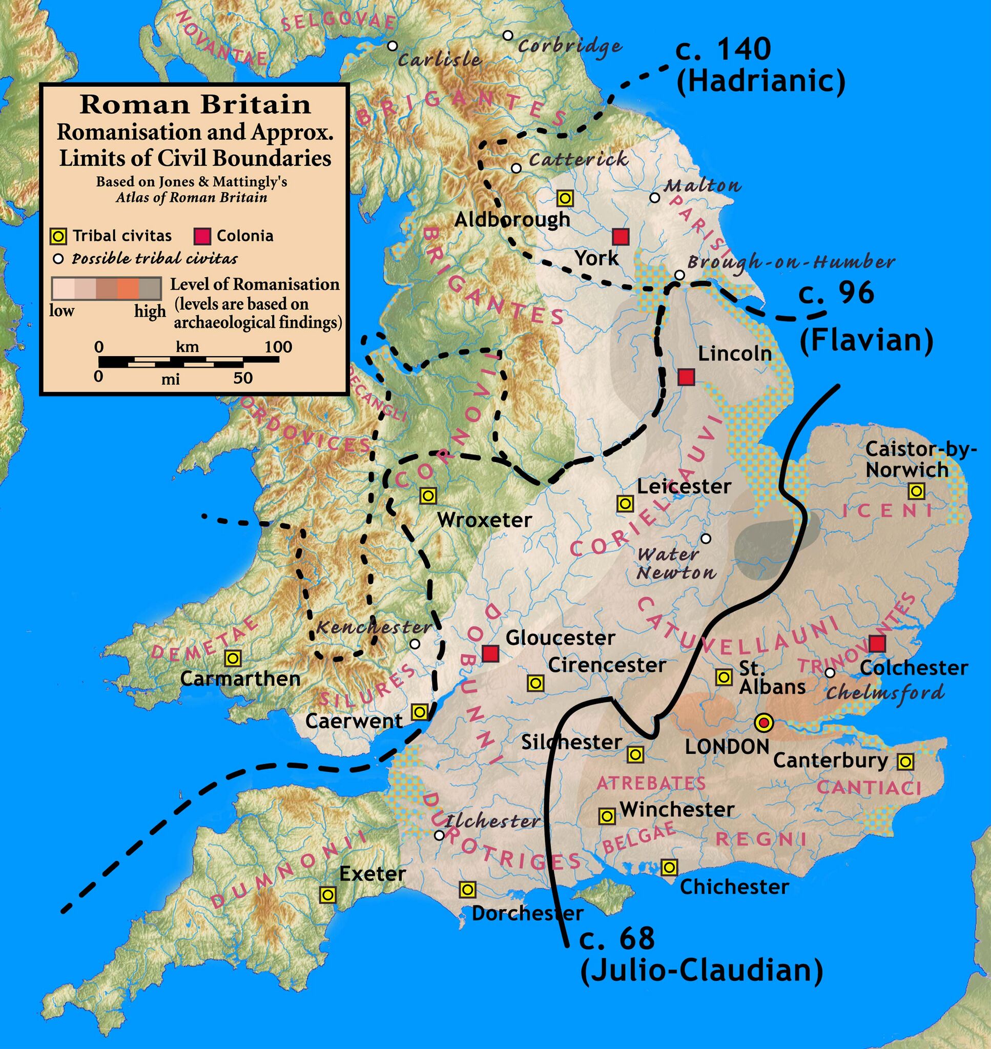
| Описание | Roman Britain — Levels of Romanisation and Approximate Limits of Civil Boundaries |
|---|---|
| Источник | Based on Jones & Mattingly's Atlas of Roman Britain (ISBN 978-1-84217-06700, 1990, reprinted 2007) — the source is cited in the image legend — Approximate civil boundaries, civitates, and coloniae are given on page 154. Levels of Romanisation ("boundaries of acculturation" with levels from "high density" to "low density" in the text) are given on page 151, with the authors citing it as a computer-generated map based on data contained in the standard Ordnance Survey map of Roman Britain. The topographical map is from a sub-region of File:Uk topo en.jpg, with the copyright notice Шаблон:Bild-GFDL-GMT and original date of 7 July 2006, copy made in 2008, with the annotations removed by myself. |
| Время создания | 2010-09-08 |
| Автор или правообладатель | my work — Лицензия: CC BY-SA 3.0 (Creative Commons Attribution-Share Alike 3.0) https://creativecommons.org/licenses/by-sa/3.0 |
| Другие версии файла | — |
Источник файла — сайт Wikimedia Commons, куда он был загружен под одной из свободных лицензий ( https://commons.wikimedia.org/wiki/File:Roman.Britain.Romanisation.jpg ). Авторов, работавших над этим файлом см. в истории файла: https://commons.wikimedia.org/w/index.php?title=File:Roman.Britain.Romanisation.jpg&action=history
В общем случае в статьях энциклопедии Руниверсалис файлы используются в соответствии со статьёй 1274 Гражданского кодекса Российской Федерации.
История файла
Нажмите на дату/время, чтобы увидеть версию файла от того времени.
| Дата/время | Миниатюра | Размеры | Участник | Примечание | |
|---|---|---|---|---|---|
| текущий | 20:29, 1 сентября 2023 | | 3000 × 3176 (924 КБ) | Я, робот (обсуждение | вклад) | == Описание == {{Изображение | описание = Roman Britain — Levels of Romanisation and Approximate Limits of Civil Boundaries | источник = <p>Based on Jones & Mattingly's <i>Atlas of Roman Britain</i> (ISBN 978-1-84217-06700, 1990, reprinted 2007) — the source is cited in the image legend — Approximate civil boundaries, civitates, and coloniae are given on page 154. Levels of Romanisation ("boundaries of acculturation" with levels from "high density" to "low density" in the text) are given... |
Вы не можете перезаписать этот файл.
Использование файла
Следующий файл является дубликатом этого файла (подробности):
- Файл:Roman.Britain.Romanisation.jpg из на Викискладе
Следующие 2 страницы используют этот файл: