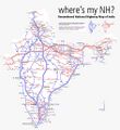
Файл:Renumbered National Highways map of India (Schematic).jpg

Исходный файл (937 × 1024 пкс, размер файла: 382 КБ, MIME-тип: image/jpeg)
Описание
| Описание | I have always been itching to make a graphic that shows the full network with the numbers which I have never been able to find. The officially notified new numbering scheme for the NH network depending on its orientation and its geographical position. Using my old File:India_roadway_map.svg as a base, I carefully plotted all the missing links and new highways on paper. Not only is this the first ever visualization of the new numbering scheme but also the most complete and updated map of the NH network you will find anywhere. Apart from being a good visual reference, the map also helps to identify issues in the new numbering scheme caused by strictly following the east-west and north-south orientation rules. |
|---|---|
| Источник | originally posted to Flickr as Renumbered National Highways map of India (Schematic) |
| Время создания | 2010-09-16 20:56:35 |
| Автор или правообладатель | Arun Ganesh — Лицензия: CC BY-SA 2.0 (Creative Commons Attribution-Share Alike 2.0) https://creativecommons.org/licenses/by-sa/2.0 |
| Другие версии файла | — |
Источник файла — сайт Wikimedia Commons, куда он был загружен под одной из свободных лицензий ( https://commons.wikimedia.org/wiki/File:Renumbered_National_Highways_map_of_India_(Schematic).jpg ). Авторов, работавших над этим файлом см. в истории файла: https://commons.wikimedia.org/w/index.php?title=File:Renumbered_National_Highways_map_of_India_(Schematic).jpg&action=history
В общем случае в статьях энциклопедии Руниверсалис файлы используются в соответствии со статьёй 1274 Гражданского кодекса Российской Федерации.
История файла
Нажмите на дату/время, чтобы увидеть версию файла от того времени.
| Дата/время | Миниатюра | Размеры | Участник | Примечание | |
|---|---|---|---|---|---|
| текущий | 10:20, 2 декабря 2023 |  | 937 × 1024 (382 КБ) | Я, робот (обсуждение | вклад) | == Описание == {{Изображение | описание = <p>I have always been itching to make a graphic that shows the full network with the numbers which I have never been able to find. </p><p>The officially notified new numbering scheme for the NH network depending on its orientation and its geographical position. </p><p>Using my old [https://commons.wikimedia.org/wiki/File:India_roadway_map.svg File:India_roadway_map.svg] as a base, I carefully plotted all the missing links and new highways on paper.... |
Вы не можете перезаписать этот файл.
Использование файла
Следующий файл является дубликатом этого файла (подробности):
- Файл:Renumbered National Highways map of India (Schematic).jpg из на Викискладе
Следующая страница использует этот файл: