Файл:Opportunity at Victoria Crater from Mars reconnaissance orbiter.jpg

Исходный файл (1941 × 1230 пкс, размер файла: 1,15 Мб, MIME-тип: image/jpeg)
Описание
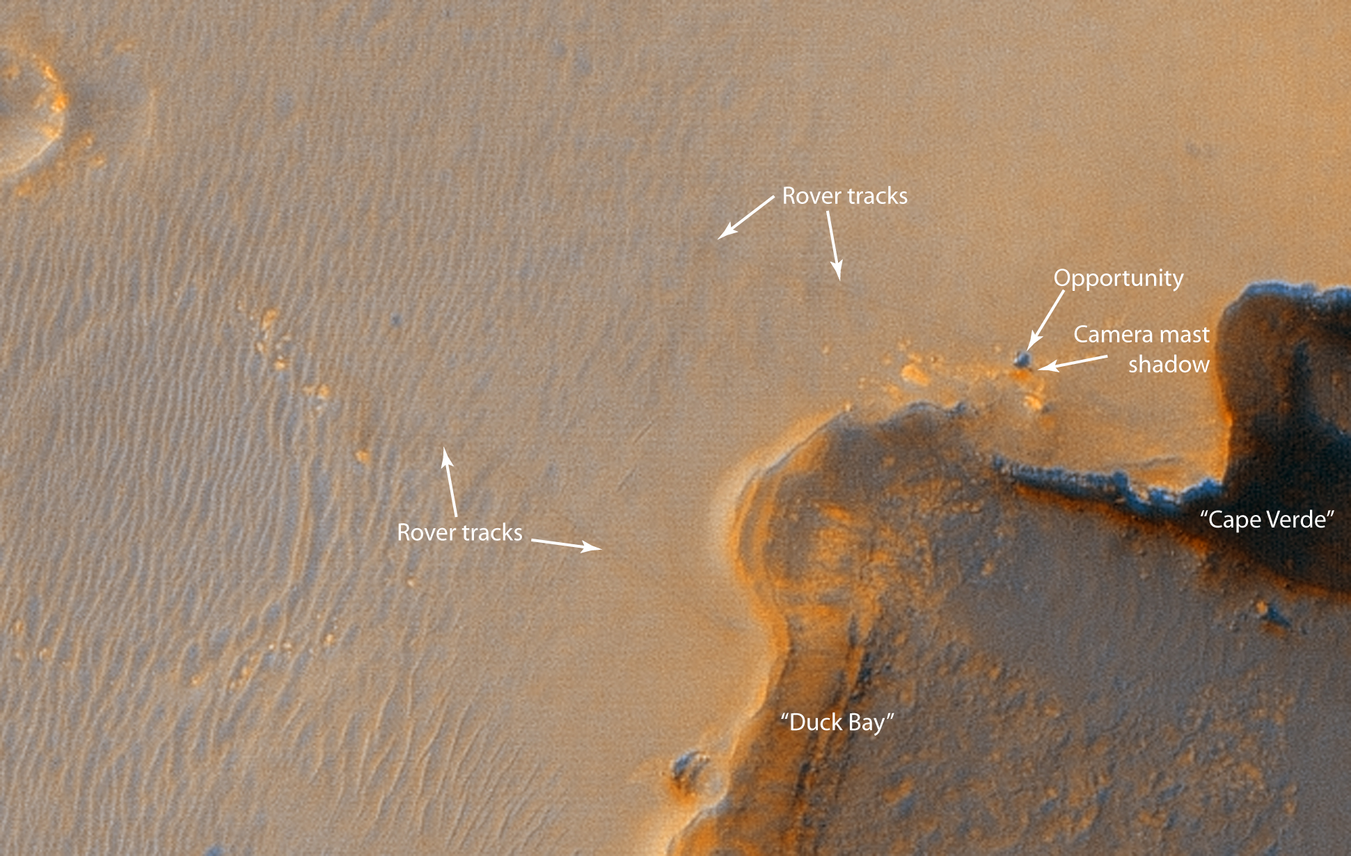
| Описание | Summary- Mars Rover "Opportunity" at Victoria crater, as viewed from orbit on October 3, 2006. Note the shadow of the rover's camera mast.
Original JPL site caption: "This image from the High Resolution Imaging Science Experiment on NASA's Mars Reconnaissance Orbiter shows the Mars Exploration Rover Opportunity near the rim of "Victoria Crater." Victoria is an impact crater about 800 meters (half a mile) in diameter at Meridiani Planum near the equator of Mars. Opportunity has been operating on Mars since January, 2004. Five days before this image was taken, Opportunity arrived at the rim of Victoria, after a drive of more than 9 kilometers (over 5 miles). It then drove to the position where it is seen in this image. Shown in the image are "Duck Bay," the eroded segment of the crater rim where Opportunity first arrived at the crater; "Cabo Frio," a sharp promontory to the south of Duck Bay; and "Cape Verde," another promontory to the north. When viewed at the highest resolution, this image shows the rover itself, wheel tracks in the soil behind it, and the rover's shadow, including the shadow of the camera mast. After this image was taken, Opportunity moved to the very tip of Cape Verde to perform more imaging of the interior of the crater. This view is a portion of an image taken by the High Resolution Imaging Science Experiment (HiRISE) camera onboard the Mars Reconnaissance Orbiter spacecraft on Oct. 3, 2006. The complete image is centered at minus7.8 degrees latitude, 279.5 degrees East longitude. The range to the target site was 297 kilometers (185.6 miles). At this distance the image scale is 29.7 centimeters (12 inches) per pixel (with 1 x 1 binning) so objects about 89 centimeters (35 inches) across are resolved. North is up. The image was taken at a local Mars time of 3:30 PM and the scene is illuminated from the west with a solar incidence angle of 59.7 degrees, thus the sun was about 30.3 degrees above the horizon." |
|---|---|
| Источник | http://photojournal.jpl.nasa.gov/figures/PIA08816_fig1.jpg |
| Время создания | 2006-10-03 |
| Автор или правообладатель | NASA/JPL/University of Arizona — Лицензия: Public domain (в общественном достоянии) |
| Другие версии файла | — |
Источник файла — сайт Wikimedia Commons, куда он был загружен под одной из свободных лицензий ( https://commons.wikimedia.org/wiki/File:Opportunity_at_Victoria_Crater_from_Mars_reconnaissance_orbiter.jpg ). Авторов, работавших над этим файлом см. в истории файла: https://commons.wikimedia.org/w/index.php?title=File:Opportunity_at_Victoria_Crater_from_Mars_reconnaissance_orbiter.jpg&action=history
В общем случае в статьях энциклопедии Руниверсалис файлы используются в соответствии со статьёй 1274 Гражданского кодекса Российской Федерации.
История файла
Нажмите на дату/время, чтобы увидеть версию файла от того времени.
| Дата/время | Миниатюра | Размеры | Участник | Примечание | |
|---|---|---|---|---|---|
| текущий | 13:06, 12 августа 2023 | | 1941 × 1230 (1,15 Мб) | Я, робот (обсуждение | вклад) | == Описание == {{Изображение | описание = Summary- Mars Rover "Opportunity" at Victoria crater, as viewed from orbit on October 3, 2006. Note the shadow of the rover's camera mast. <p>Original JPL site caption: "This image from the High Resolution Imaging Science Experiment on NASA's Mars Reconnaissance Orbiter shows the Mars Exploration Rover Opportunity near the rim of "Victoria Crater." Victoria is an impact crater about 800 meters (half a mile) in diameter at Meridiani Planum near the e... |
Вы не можете перезаписать этот файл.
Использование файла
Следующий файл является дубликатом этого файла (подробности):
Следующие 4 страницы используют этот файл: