Файл:Ming-Expeditions.svg

Исходный файл (SVG-файл, номинально 1100 × 837 пкс, размер файла: 546 Кб)
Описание
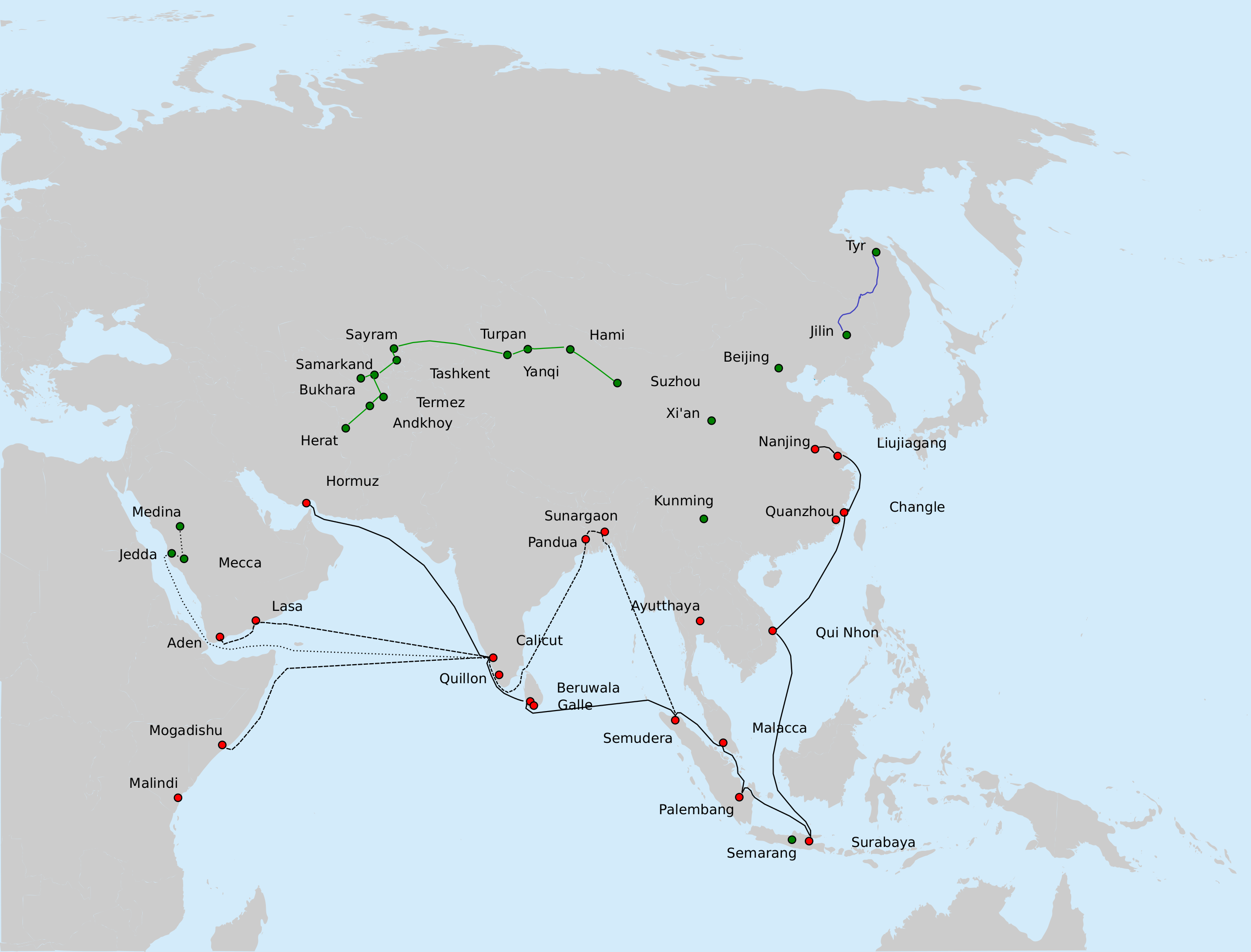
| Описание | Some of the major long-distance military-diplomatic expeditions of the Yongle and Xuande reigns of the Ming Dynasty (1402-1435).
BLACK: Route of the 7th expedition of Zheng He's fleet (1431-1433).
The previous 6 expeditions went along similar routes (the first 3, only to Calicut; 3rd through 6th, to Hormuz and other points in Africa/Arabia). BLUE: Yishiha's expeditions from Jilin down the Sungari and the Amur to Tyr (Telin) (1411-1426) GREEN: Approximate route of Chen Cheng, an envoy to the Timurid Empire (1414, 1416, 1420) Sources: The main source for Zheng He routes: chapter on the last expedition of Zheng He in: Dreyer E. L., Zheng He: China and the Oceans in the Early Ming Dynasty, 1405-1433. — Longman, 2007. — 256 p. — (Library of World Biography Series). — ISBN 0321084438. The cities in Bengal are given as per : Barbosa, Duarte & Dames, Mansel Longworth (1996), An Account Of The Countries Bordering On The Indian Ocean And Their Inhabitants; Written By Duarte Barbosa And Completed About The Year 1518 A.D. Vol 1: Including The Coasts Of East Africa, Arabia, Persia And Western India As Far As The Kingdom Of Vijayanagar. Vol. Ii: Including The Coasts Of Malabar, Eastern India, Further India, China And The Indian Archipelago., Asian Educational Services, pp. 138-139, ISBN 8120604512 The routes of Yishiha and Chen Cheng are based on the descriptions in the articles "Isiha" and "Ch'en Ch'eng" in: Goodrich, L. Carrington; Fang, Chaoying, eds. (1976), Dictionary of Ming Biography, 1368–1644. Volume I (A-L), Columbia University Press, pp. 685–686, ISBN 0-231-03801-1 |
|---|---|
| Источник | Own work |
| Время создания | 2010-08-24 |
| Автор или правообладатель | Vmenkov, based on the blank map File:Asie.svg (ver. 1) by User:Historicair — Лицензия: CC BY 1.0 (Creative Commons Attribution 1.0) https://creativecommons.org/licenses/by/1.0 |
| Другие версии файла | — |
Источник файла — сайт Wikimedia Commons, куда он был загружен под одной из свободных лицензий ( https://commons.wikimedia.org/wiki/File:Ming-Expeditions.svg ). Авторов, работавших над этим файлом см. в истории файла: https://commons.wikimedia.org/w/index.php?title=File:Ming-Expeditions.svg&action=history
В общем случае в статьях энциклопедии Руниверсалис файлы используются в соответствии со статьёй 1274 Гражданского кодекса Российской Федерации.
История файла
Нажмите на дату/время, чтобы увидеть версию файла от того времени.
| Дата/время | Миниатюра | Размеры | Участник | Примечание | |
|---|---|---|---|---|---|
| текущий | 13:05, 12 августа 2023 | | 1100 × 837 (546 Кб) | I, Robot (обсуждение | вклад) | == Описание == {{Изображение | описание = Some of the major long-distance military-diplomatic expeditions of the Yongle and Xuande reigns of the Ming Dynasty (1402-1435). <p>BLACK: Route of the 7th expedition of Zheng He's fleet (1431-1433). </p> <ul><li>Solid line: the route of the main fleet from Nanjing to Hormuz, as described in <i>Xia Xiyang</i> (下西洋).</li> <li>Dashed line: a possible route of Hong Bao's squadron, to Bengal, Arabia and Africa, based on suggestions made in Dreyer (2007)... |
Вы не можете перезаписать этот файл.
Использование файла
Следующий файл является дубликатом этого файла (подробности):
- Файл:Ming-Expeditions.svg из на Викискладе
Следующие 3 страницы используют этот файл: