
Файл:MGS MOC Wide Angle Map of Mars PIA03467.jpg
Исходный файл (2000 × 1288 пкс, размер файла: 534 КБ, MIME-тип: image/jpeg)
Описание
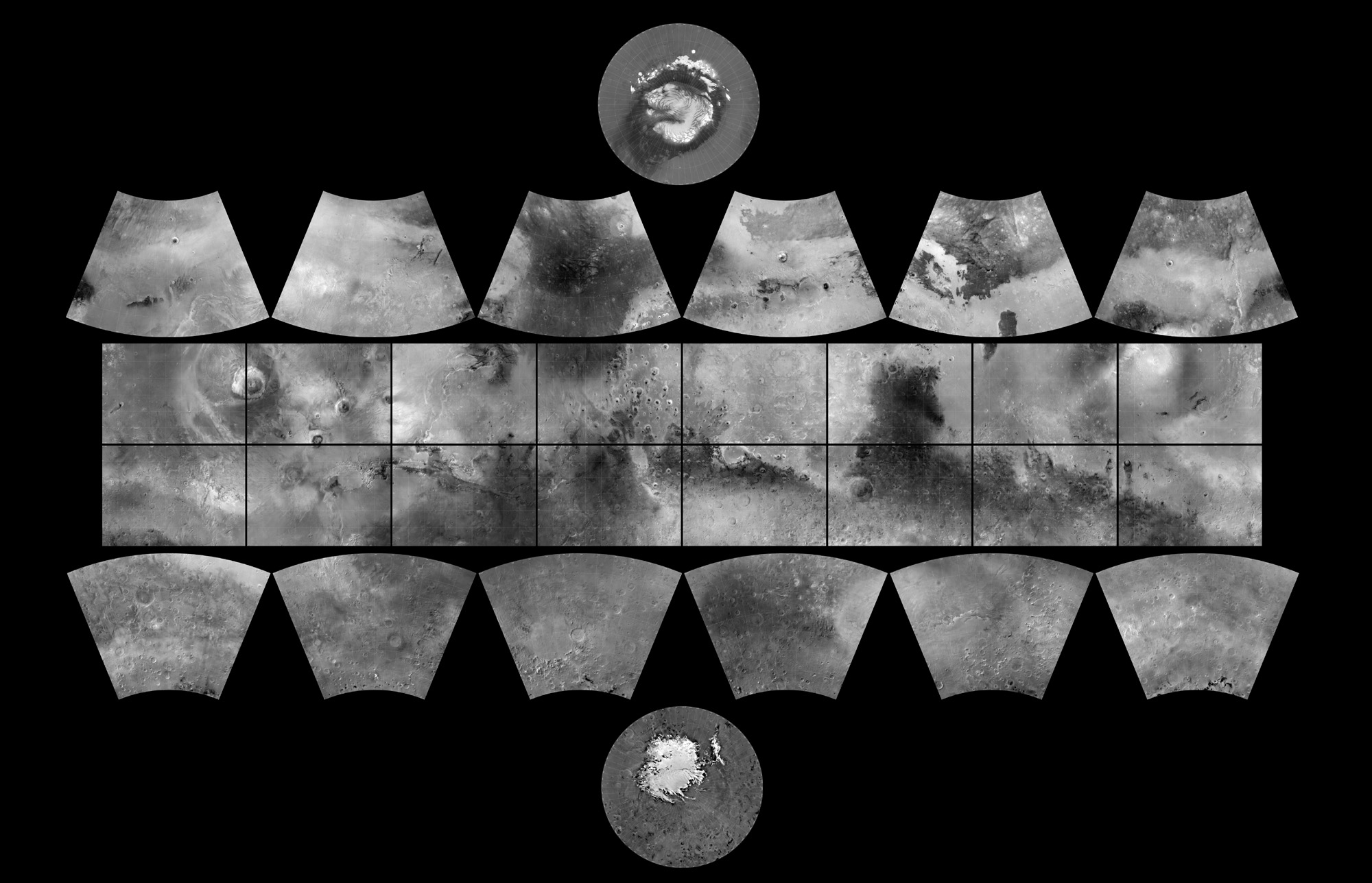
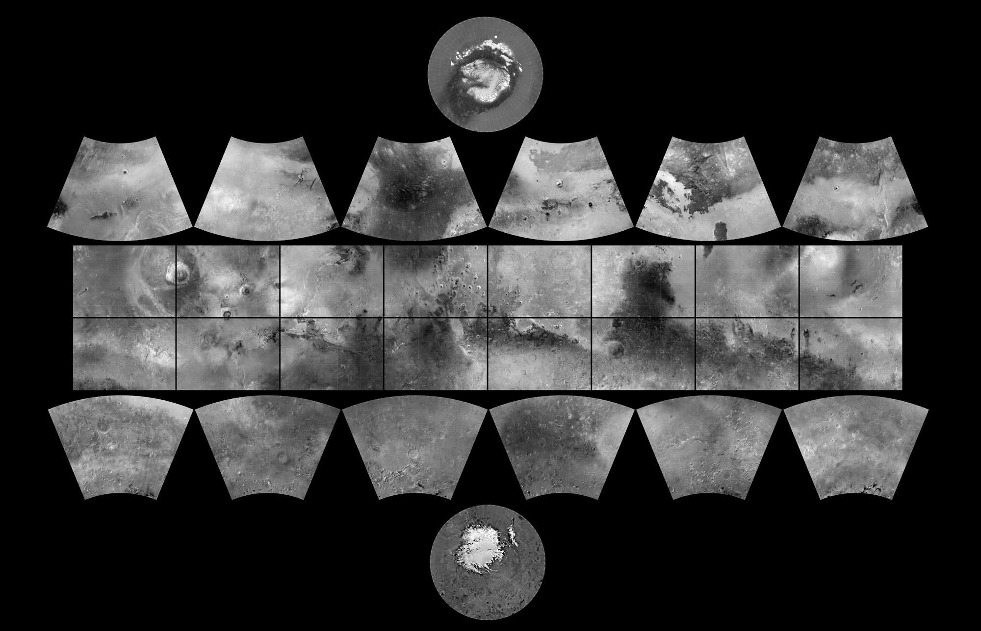
| Описание | The MGS MOC Wide Angle Map of Mars
In 1979, NASA published ATLAS OF MARS: THE 1:5,000,000 MAP SERIES, edited by R.M. Batson, P.M. Bridges, and J.L. Inge, of the U.S. Geological Survey in Flagstaff, Arizona. This was a compendium of airbrushed shaded relief maps, controlled photomosaics, and in a few cases albedo (shading) maps, mostly assembled from Mariner 9 survey images, with some gaps filled by Viking orbiter images. The planet was divided into thirty "quadrangles" or areas, each with an "Mars Chart" or "MC" number (MC-1 through MC-30). The equatorial region was portrayed in the Mercator projection, with Lambert Conformal Conic for the mid-latitudes and Polar Stereographic for the poles. Although digital products such as the Mars Digital Image Mosaic (MDIM) and various Mars Global Surveyor (MGS) Mars Orbiter Laser Altimeter (MOLA) maps have partially supplanted the ATLAS, it remains a standard desktop reference today. In 1999, the Mars Orbiter Camera (MOC) aboard the MGS orbiter acquired a global stereo image dataset using its red-filter Wide Angle Camera. We have recently completed a 256 pixel/degree (about 230 meters/pixel) mosaic of these images using software developed at Malin Space Science Systems(MSSS). Visit the MSSS Geodesy Campaign Mosaic Page to access both partial and full-resolution mosaics in Planetary Data System format. The image above is a reproduction of the new MGS MOC Mars Digital Map and is the first of several cartographic products that MSSS expects to release this year. Malin Space Science Systems and the California Institute of Technology built the MOC using spare hardware from the Mars Observer mission. MSSS operates the camera from its facilities in San Diego, CA. The Jet Propulsion Laboratory's Mars Surveyor Operations Project operates the Mars Global Surveyor spacecraft with its industrial partner, Lockheed Martin Astronautics, from facilities in Pasadena, CA and Denver, CO. |
|---|---|
| Источник | http://photojournal.jpl.nasa.gov/catalog/PIA03467 (image link) |
| Время создания | 2002-02-16 |
| Автор или правообладатель | NASA/JPL/MSSS — Лицензия: Public domain (в общественном достоянии) |
| Другие версии файла | — |
Источник файла — сайт Wikimedia Commons, куда он был загружен под одной из свободных лицензий ( https://commons.wikimedia.org/wiki/File:MGS_MOC_Wide_Angle_Map_of_Mars_PIA03467.jpg ). Авторов, работавших над этим файлом см. в истории файла: https://commons.wikimedia.org/w/index.php?title=File:MGS_MOC_Wide_Angle_Map_of_Mars_PIA03467.jpg&action=history
В общем случае в статьях энциклопедии Руниверсалис файлы используются в соответствии со статьёй 1274 Гражданского кодекса Российской Федерации.
История файла
Нажмите на дату/время, чтобы увидеть версию файла от того времени.
| Дата/время | Миниатюра | Размеры | Участник | Примечание | |
|---|---|---|---|---|---|
| текущий | 13:12, 19 ноября 2023 | | 2000 × 1288 (534 КБ) | Я, робот (обсуждение | вклад) | == Описание == {{Изображение | описание = <b>The MGS MOC Wide Angle Map of Mars</b> <ul><li>Target Name: Mars</li> <li>Is a satellite of: Sol (our sun)</li> <li>Mission: Mars Global Surveyor (MGS)</li> <li>Spacecraft: Mars Global Surveyor Orbiter</li> <li>Instrument: Mars Orbiter Camera (MOC)</li> <li>Product Size: 2000 x 1288 pixels (width x height)</li> <li>Produced By: Malin Space Science Systems</li> <li>Producer ID: MOC2-299</li> <li>Primary Data Set: MGS EDRs</li></ul><p>In 1979,... |
Вы не можете перезаписать этот файл.
Использование файла
Следующий файл является дубликатом этого файла (подробности):
- Файл:MGS MOC Wide Angle Map of Mars PIA03467.jpg на Викискладе
Следующая страница использует этот файл: