
Файл:Kingdom of the Isles, circa 1200 (png version) 02.png
Исходный файл (672 × 850 пкс, размер файла: 202 КБ, MIME-тип: image/png)
Описание
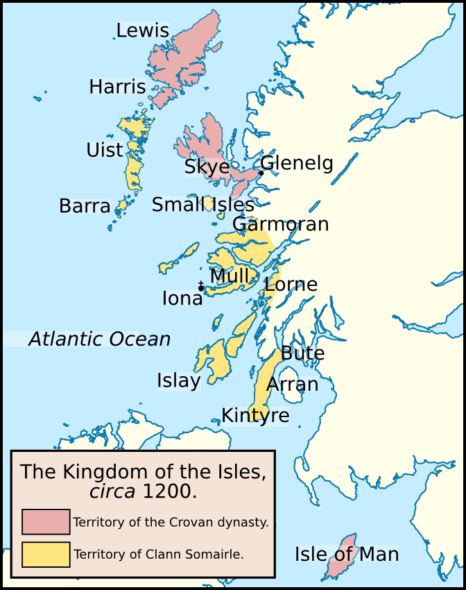
| Описание | Map of the Kingdom of the Isles in about 1200. The lands controlled by the Crovan dynasty are coloured red; the lands controlled by the descendants of Somerled (Clann Somairle) are coloured yellow. Locations displayed on this map include: the Atlantic Ocean, Arran, Barra, Bute, Garmoran, Glenelg, Harris, Iona, Islay, Isle of Man, Kintyre, Lewis, Lorne, Mull, Skye, the Small Isles, and Uist. I based this map off one published in the following book: McDonald, R.A. (2007). Manx Kingship in its Irish sea Setting, 1187–1229: King Rǫgnvaldr and the Crovan dynasty. Four Courts Press. 978-1-84682-047-2. |
|---|---|
| Источник | Own work. I created this image using Inkscape. I used the following image, created by NordNordWest: File:United_Kingdom_location_map.svg. |
| Время создания | 2011-10-30 |
| Автор или правообладатель | Brianann MacAmhlaidh — Лицензия: CC BY-SA 3.0 (Creative Commons Attribution-Share Alike 3.0) https://creativecommons.org/licenses/by-sa/3.0 |
| Другие версии файла | — |
Источник файла — сайт Wikimedia Commons, куда он был загружен под одной из свободных лицензий ( https://commons.wikimedia.org/wiki/File:Kingdom_of_the_Isles,_circa_1200_(png_version)_02.png ). Авторов, работавших над этим файлом см. в истории файла: https://commons.wikimedia.org/w/index.php?title=File:Kingdom_of_the_Isles,_circa_1200_(png_version)_02.png&action=history
_02.png)
_02.png&action=history)
В общем случае в статьях энциклопедии Руниверсалис файлы используются в соответствии со статьёй 1274 Гражданского кодекса Российской Федерации.
История файла
Нажмите на дату/время, чтобы увидеть версию файла от того времени.
| Дата/время | Миниатюра | Размеры | Участник | Примечание | |
|---|---|---|---|---|---|
| текущий | 22:00, 11 августа 2023 | | 672 × 850 (202 КБ) | I, Robot (обсуждение | вклад) | == Описание == {{Изображение | описание = Map of the [https://en.wikipedia.org/wiki/Kingdom_of_the_Isles Kingdom of the Isles] in about 1200. The lands controlled by the [https://en.wikipedia.org/wiki/Crovan_dynasty Crovan dynasty] are coloured red; the lands controlled by the descendants of [https://en.wikipedia.org/wiki/Somerled Somerled] (<i>[https://en.wikipedia.org/wiki/Clann_Somairle Clann Somairle]</i>) are coloured yellow. Locations displayed on this map include: the [https://en.wiki... |
Вы не можете перезаписать этот файл.
Использование файла
Следующий файл является дубликатом этого файла (подробности):
_02.png)
- Файл:Kingdom of the Isles, circa 1200 (png version) 02.png из на Викискладе
Следующие 3 страницы используют этот файл:
_02.png&oldid=16496914)