
Файл:Hurricane Emily 16 july 2005 1545Z.jpg

Исходный файл (4480 × 5760 пкс, размер файла: 1,13 МБ, MIME-тип: image/jpeg)
Описание
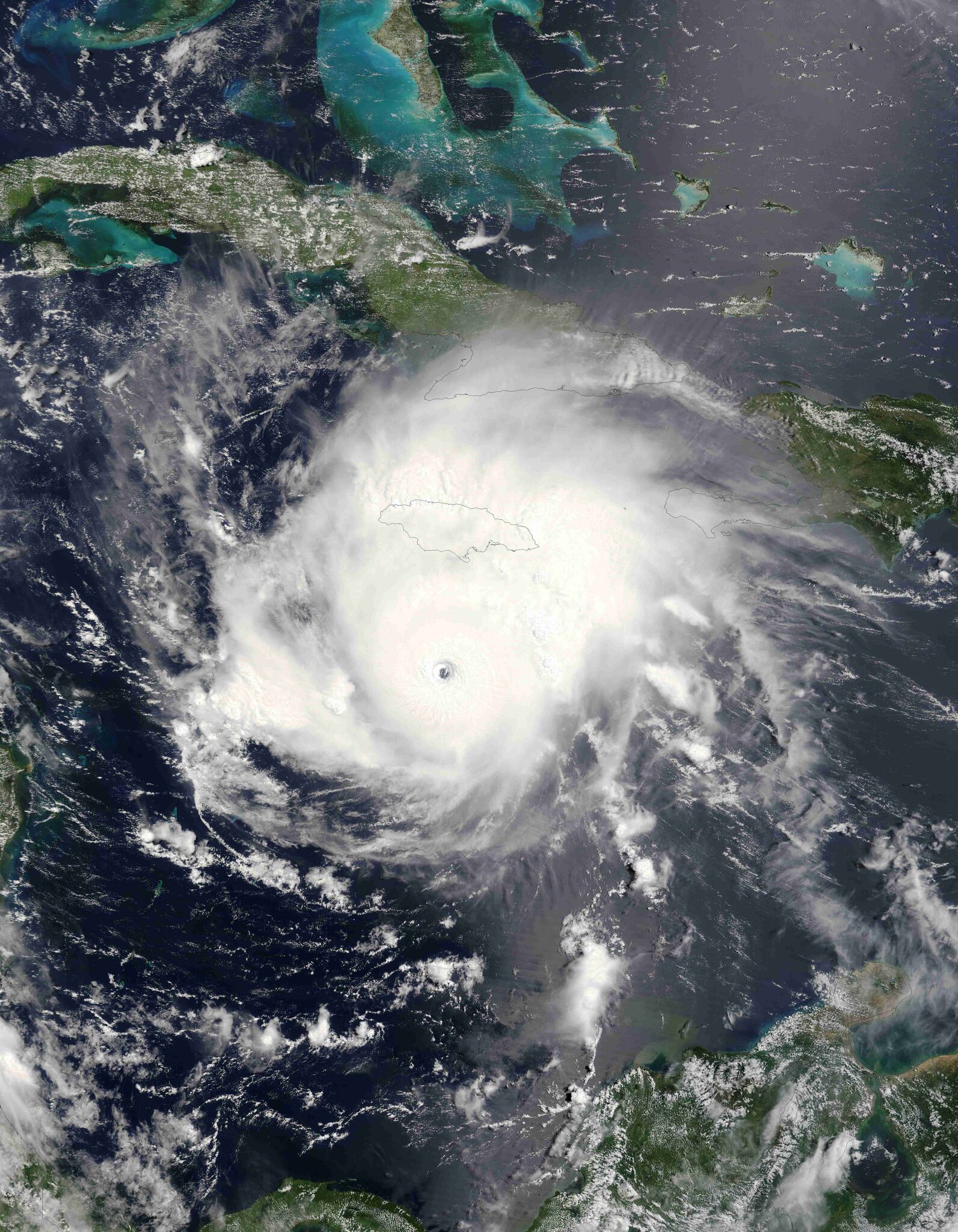
| Описание | Hurricane Emily was spinning through the Caribbean south of Jamacia on July 16, 2005, when the Moderate Resolution Imaging Spectroradiometer (MODIS) on the Terra satellite captured this image at 15:45 UTC (11:45 a.m. Eastern Daylight Time). At this time, Emily was a well-developed hurricane with winds over 230 kilometers an hour (125 knots) and gusts as high as 285 km/hr (155 knots). As shown in this satellite image, the storm is passing roughly east to west well south of Jamaica (around 160 kilometers, or 100 miles), but the heavy rains in the storm's outer bands fell on an already sodden island still recovering from Hurricane Dennis, which similarly glanced the island on July 7. Emily's rains caused flooding, which has resulted in four deaths on the island. Tourists in the Yucatan Peninsula are being evacuated from resort areas and beaches as the hurricane continues on track to make landfall there during the morning of July 18, 2005. |
|---|---|
| Источник | http://earthobservatory.nasa.gov/NaturalHazards/natural_hazards_v2.php3?img_id=12967 |
| Время создания | 2005-07-16 |
| Автор или правообладатель | NASA image provided courtesy of Jeff Schmaltz, MODIS Rapid Response team. — Лицензия: Public domain (в общественном достоянии) |
| Другие версии файла | — |
Источник файла — сайт Wikimedia Commons, куда он был загружен под одной из свободных лицензий ( https://commons.wikimedia.org/wiki/File:Hurricane_Emily_16_july_2005_1545Z.jpg ). Авторов, работавших над этим файлом см. в истории файла: https://commons.wikimedia.org/w/index.php?title=File:Hurricane_Emily_16_july_2005_1545Z.jpg&action=history
В общем случае в статьях энциклопедии Руниверсалис файлы используются в соответствии со статьёй 1274 Гражданского кодекса Российской Федерации.
История файла
Нажмите на дату/время, чтобы увидеть версию файла от того времени.
| Дата/время | Миниатюра | Размеры | Участник | Примечание | |
|---|---|---|---|---|---|
| текущий | 06:30, 24 октября 2023 | | 4480 × 5760 (1,13 МБ) | Я, робот (обсуждение | вклад) | == Описание == {{Изображение | описание = <p>Hurricane Emily was spinning through the Caribbean south of Jamacia on July 16, 2005, when the Moderate Resolution Imaging Spectroradiometer (MODIS) on the Terra satellite captured this image at 15:45 UTC (11:45 a.m. Eastern Daylight Time). At this time, Emily was a well-developed hurricane with winds over 230 kilometers an hour (125 knots) and gusts as high as 285 km/hr (155 knots). </p> As shown in this satellite image, the storm is passing roug... |
Вы не можете перезаписать этот файл.
Использование файла
Следующая страница использует этот файл: