
Файл:Europe 1097-corrected.jpg
Исходный файл (1816 × 1260 пкс, размер файла: 269 КБ, MIME-тип: image/jpeg)
Описание
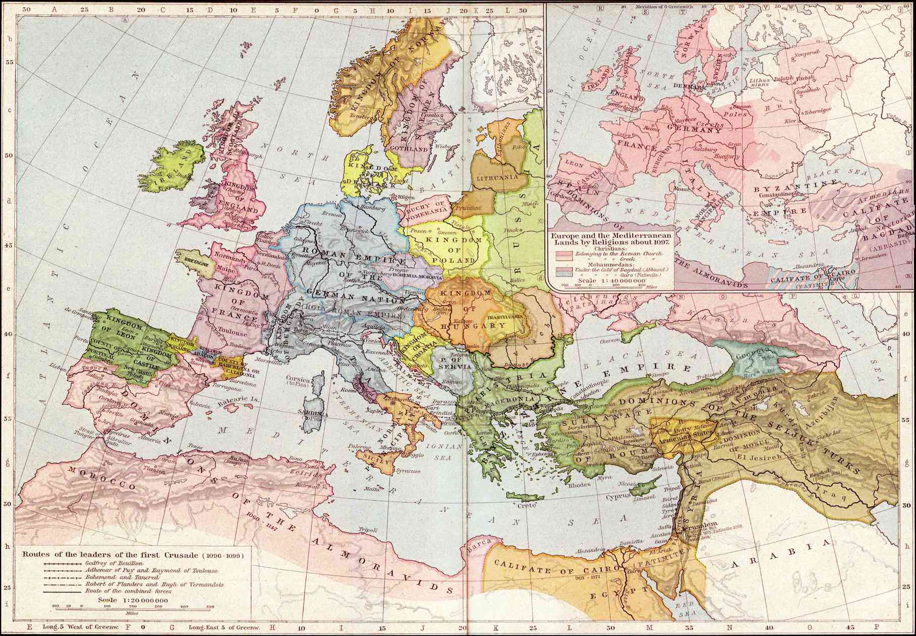
| Описание | Modified version of William Shepherd's map File:Europe_mediterranean_1097.jpg; motivation: in 1097 the Byzantine Empire had not been completely excluded from entire Anatolia (after Mantzikert, 1071) and the lower Danube was not pagan, even if Pechenegs were Tengrists. A modification according with primary sources about Byzantine Empire & Eastern Europe, is a derivative map from the work of William Shepherd which is false in Anatolia (represented as entirely Seljuk except two very reduced areas around Sinop & Trebizond, but a very enlarged area around armenian Cilicia) and in the eastern Europe (where the orthodox continuity is lacking through eastern Hungary & the Pecheng & Cuman area, between the Byzantine Empire and the Rus'). "Altered" ans "deviates" are pejorative expressions which suggest that Shepherd's version would be historically "accurate" and this one "inaccurate" : see also the discussion file. | ||||
|---|---|---|---|---|---|
| Источник | Historical Atlas by William Shepherd (1923-26) <tbody></tbody><tbody></tbody>
| ||||
| Время создания | 2007-01-29 20:27:48 | ||||
| Автор или правообладатель | Claude Zygiel — Лицензия: Public domain (в общественном достоянии) | ||||
| Другие версии файла | — | ||||
Источник файла — сайт Wikimedia Commons, куда он был загружен под одной из свободных лицензий ( https://commons.wikimedia.org/wiki/File:Europe_1097-corrected.jpg ). Авторов, работавших над этим файлом см. в истории файла: https://commons.wikimedia.org/w/index.php?title=File:Europe_1097-corrected.jpg&action=history
В общем случае в статьях энциклопедии Руниверсалис файлы используются в соответствии со статьёй 1274 Гражданского кодекса Российской Федерации.
История файла
Нажмите на дату/время, чтобы увидеть версию файла от того времени.
| Дата/время | Миниатюра | Размеры | Участник | Примечание | |
|---|---|---|---|---|---|
| текущий | 00:18, 9 октября 2023 | | 1816 × 1260 (269 КБ) | I, Robot (обсуждение | вклад) | == Описание == {{Изображение | описание = Modified version of William Shepherd's map [https://commons.wikimedia.org/wiki/File:Europe_mediterranean_1097.jpg File:Europe_mediterranean_1097.jpg]; motivation: in 1097 the Byzantine Empire had not been completely excluded from entire Anatolia (after Mantzikert, 1071) and the lower Danube was not pagan, even if Pechenegs were Tengrists. A modification according with primary sources about Byzantine Empire & Eastern Europe, is a derivative map fr... |
Вы не можете перезаписать этот файл.
Использование файла
Следующая страница использует этот файл: