Файл:Dean 2007 track.png
Размер этого предпросмотра: 800 × 494 пкс. Другое разрешение: 2160 × 1335 пкс.
Исходный файл (2160 × 1335 пкс, размер файла: 1,41 Мб, MIME-тип: image/png)
Описание
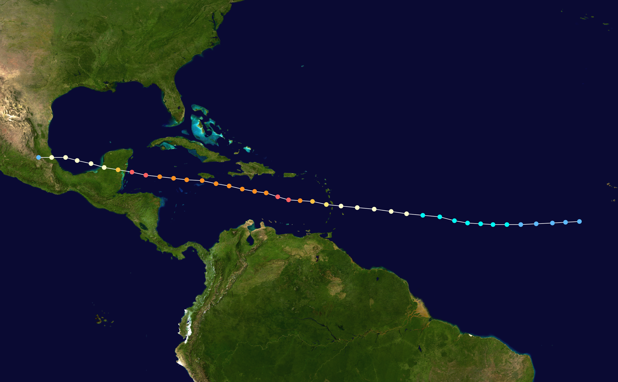
| Описание | Track map of Hurricane Dean of the 2007 Atlantic hurricane season. The points show the location of the storm at 6-hour intervals. The colour represents the storm's maximum sustained wind speeds as classified in the (see below), and the shape of the data points represent the nature of the storm, according to the legend below.
<style data-mw-deduplicate="TemplateStyles:r714798474">.mw-parser-output .div-col{margin-top:.3em;column-width:30em}.mw-parser-output .div-col-small{font-size:90%}.mw-parser-output .div-col-rules{column-rule:thin solid #AAA}.mw-parser-output .div-col dl,.mw-parser-output .div-col ol,.mw-parser-output .div-col ul{margin-top:0}.mw-parser-output .div-col li,.mw-parser-output .div-col dd{page-break-inside:avoid;break-inside:avoid-column}</style>
Tropical depression (≤38 mph, ≤62 km/h)
Tropical storm (39–73 mph, 63–118 km/h)
Category 1 (74–95 mph, 119–153 km/h)
Category 2 (96–110 mph, 154–177 km/h)
Category 3 (111–129 mph, 178–208 km/h)
Category 4 (130–156 mph, 209–251 km/h)
Category 5 (≥157 mph, ≥252 km/h)
Unknown
Storm type <img alt="●" class="mw-file-element" data-file-height="512" data-file-width="512" decoding="async" height="18" src="https://upload.wikimedia.org/wikipedia/commons/thumb/2/27/Disc_Plain_black.svg/18px-Disc_Plain_black.svg.png" srcset="https://upload.wikimedia.org/wikipedia/commons/thumb/2/27/Disc_Plain_black.svg/27px-Disc_Plain_black.svg.png 1.5x, https://upload.wikimedia.org/wikipedia/commons/thumb/2/27/Disc_Plain_black.svg/36px-Disc_Plain_black.svg.png 2x" width="18"/> Tropical cyclone
<img alt="■" class="mw-file-element" data-file-height="512" data-file-width="512" decoding="async" height="18" src="https://upload.wikimedia.org/wikipedia/commons/thumb/2/21/Solid_black.svg/18px-Solid_black.svg.png" srcset="https://upload.wikimedia.org/wikipedia/commons/thumb/2/21/Solid_black.svg/27px-Solid_black.svg.png 1.5x, https://upload.wikimedia.org/wikipedia/commons/thumb/2/21/Solid_black.svg/36px-Solid_black.svg.png 2x" width="18"/> Subtropical cyclone
<img alt="▲" class="mw-file-element" data-file-height="512" data-file-width="512" decoding="async" height="18" src="https://upload.wikimedia.org/wikipedia/commons/thumb/5/50/ArrowUp.svg/18px-ArrowUp.svg.png" srcset="https://upload.wikimedia.org/wikipedia/commons/thumb/5/50/ArrowUp.svg/27px-ArrowUp.svg.png 1.5x, https://upload.wikimedia.org/wikipedia/commons/thumb/5/50/ArrowUp.svg/36px-ArrowUp.svg.png 2x" width="18"/> Extratropical cyclone / Remnant low / Tropical disturbance / Monsoon depression
|
|---|---|
| Источник | Created by Supportstorm using Wikipedia:WikiProject Tropical cyclones/Tracks. The background image is from NASA. Tracking data is from the National Hurricane Center[1]. |
| Время создания | 2007-08-13–2007-08-23 |
| Автор или правообладатель | Supportstorm — Лицензия: Public domain (в общественном достоянии) |
| Другие версии файла | — |
Источник файла — сайт Wikimedia Commons, куда он был загружен под одной из свободных лицензий ( https://commons.wikimedia.org/wiki/File:Dean_2007_track.png ). Авторов, работавших над этим файлом см. в истории файла: https://commons.wikimedia.org/w/index.php?title=File:Dean_2007_track.png&action=history
В общем случае в статьях энциклопедии Руниверсалис файлы используются в соответствии со статьёй 1274 Гражданского кодекса Российской Федерации.
История файла
Нажмите на дату/время, чтобы увидеть версию файла от того времени.
| Дата/время | Миниатюра | Размеры | Участник | Примечание | |
|---|---|---|---|---|---|
| текущий | 13:16, 6 октября 2023 | | 2160 × 1335 (1,41 Мб) | Я, робот (обсуждение | вклад) | == Описание == {{Изображение | описание = Track map of [https://en.wikipedia.org/wiki/Hurricane_Dean Hurricane Dean] of the [https://en.wikipedia.org/wiki/2007_Atlantic_hurricane_season 2007 Atlantic hurricane season]. The points show the location of the storm at 6-hour intervals. The colour represents the storm's [https://en.wikipedia.org/wiki/maximum_sustained_wind maximum sustained wind speeds] as classified in the (see below), and the shape of the data points represent the nature of the... |
Вы не можете перезаписать этот файл.
Использование файла
Следующая страница использует этот файл: