Файл:Chile.CarlosPrieto.1881.jpg

Исходный файл (3803 × 2764 пкс, размер файла: 815 КБ, MIME-тип: image/jpeg)
Описание
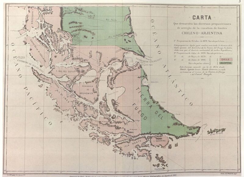
| Описание | "Official Map of the Chilean Hydrographic Office issued in August 1881 The Government of Chile had this official map issued in 1881 to illustrate both the newly signed Boundary Treaty of 23 July 1881 and the various proposals for boundary limits submitted during the course of negociations between Chile and Argentina during the years 1872, 1876 and 1879. It was drawn up by Carlos M. Prieto, an engineer of the Chilean Hydrographic Office. The terrritory asigned to Chile by the Boundary Treaty of 1881 is shown coloured in pink with the territory assigned to Argentina in green. Picton, Nueva and Lennox Islands together with all the others extending southward as far as Cape Horn are shown as assigned to Chile. This map was widely distributed both at home and abroad. It was published in the Chilean press and foreign diplomatic missions in Santiago and various foreign institutionsreceived copies of this official Chilean map." |
|---|---|
| Источник | El Conflicto del Beagle, edited by the chilean Foreign Affairs Office, 1978, Switzerland |
| Время создания | 1881 |
| Автор или правообладатель | Engineer Carlos M. Prieto of the Chilean Hydrographic Office — Лицензия: Public domain (в общественном достоянии) |
| Другие версии файла | — |
Источник файла — сайт Wikimedia Commons, куда он был загружен под одной из свободных лицензий ( https://commons.wikimedia.org/wiki/File:Chile.CarlosPrieto.1881.jpg ). Авторов, работавших над этим файлом см. в истории файла: https://commons.wikimedia.org/w/index.php?title=File:Chile.CarlosPrieto.1881.jpg&action=history
В общем случае в статьях энциклопедии Руниверсалис файлы используются в соответствии со статьёй 1274 Гражданского кодекса Российской Федерации.
История файла
Нажмите на дату/время, чтобы увидеть версию файла от того времени.
| Дата/время | Миниатюра | Размеры | Участник | Примечание | |
|---|---|---|---|---|---|
| текущий | 05:06, 28 сентября 2023 |  | 3803 × 2764 (815 КБ) | Я, робот (обсуждение | вклад) | == Описание == {{Изображение | описание = <p>"Official Map of the Chilean Hydrographic Office issued in August 1881 </p><p>The Government of Chile had this official map issued in 1881 to illustrate both the newly signed Boundary Treaty of 23 July 1881 and the various proposals for boundary limits submitted during the course of negociations between Chile and Argentina during the years 1872, 1876 and 1879. It was drawn up by Carlos M. Prieto, an engineer of the Chilean Hydrographic Office. </p... |
Вы не можете перезаписать этот файл.
Использование файла
Следующая страница использует этот файл: