Файл:Central-eastern Brazil, by Copernicus Sentinel-2A satellite.jpg

Исходный файл (9166 × 8784 пкс, размер файла: 633 КБ, MIME-тип: image/jpeg)
Описание
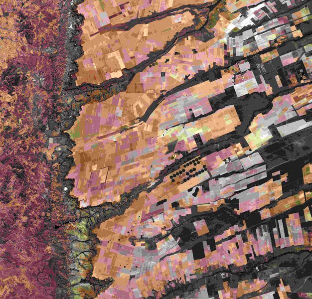
| Описание | Central-eastern Brazil, by Copernicus Sentinel-2A satellite.
Here we can see a large, flat plateau blanked with fields benefiting from rich soils and an apparent abundance of water, before falling off into a green, hilly valley (left). The straight lines in the image are roads, such as the highway running in a nearly straight line from the centre-top to bottom of the image. The area is particularly known for soybean production. The country’s soybean output has increased by more than 3000% since the 1970s, and Brazil is the second largest global producer of soybeans after the US. Other crops in this area include corn, coffee and cotton. A distinctive feature in this image is the circles – mainly at the centre. These shapes were created by a central-pivot irrigation system, where a long water pipe rotates around a well at the centre of each plot. The varying colours show different types of crop, or different stages of growth. The two-satellite Sentinel-2 mission is designed to monitor changing lands, including crop type and health. While the first satellite has been in orbit since 2015, its Sentinel-2B twin was launched on 7 March. Together, the satellites will provide new images of Earth’s land surfaces every five days. |
|---|---|
| Источник | http://www.esa.int/spaceinimages/Images/2017/04/Central-eastern_Brazil |
| Время создания | 2016-08-08 |
| Автор или правообладатель | ESA / Copernicus Sentinel-2A — Лицензия: CC BY-SA 3.0 igo (Creative Commons Attribution-Share Alike 3.0 igo) https://creativecommons.org/licenses/by-sa/3.0/igo/deed.en |
Источник файла — сайт Wikimedia Commons, куда он был загружен под одной из свободных лицензий ( https://commons.wikimedia.org/wiki/File:Central-eastern_Brazil,_by_Copernicus_Sentinel-2A_satellite.jpg ). Авторов, работавших над этим файлом см. в истории файла: https://commons.wikimedia.org/w/index.php?title=File:Central-eastern_Brazil,_by_Copernicus_Sentinel-2A_satellite.jpg&action=history
В общем случае в статьях энциклопедии Руниверсалис файлы используются в соответствии со статьёй 1274 Гражданского кодекса Российской Федерации.
История файла
Нажмите на дату/время, чтобы увидеть версию файла от того времени.
| Дата/время | Миниатюра | Размеры | Участник | Примечание | |
|---|---|---|---|---|---|
| текущий | 00:16, 27 сентября 2023 |  | 9166 × 8784 (633 КБ) | Я, робот (обсуждение | вклад) | == Описание == {{Изображение | описание = Central-eastern Brazil, by Copernicus Sentinel-2A satellite. <p>Here we can see a large, flat plateau blanked with fields benefiting from rich soils and an apparent abundance of water, before falling off into a green, hilly valley (left). The straight lines in the image are roads, such as the highway running in a nearly straight line from the centre-top to bottom of the image. </p><p>The area is particularly known for soybean production. The country’... |
Вы не можете перезаписать этот файл.
Использование файла
Следующая страница использует этот файл: