
Файл:Cartogram-2004 Electoral Vote.gif
Исходный файл (874 × 704 пкс, размер файла: 31 КБ, MIME-тип: image/gif)
Описание
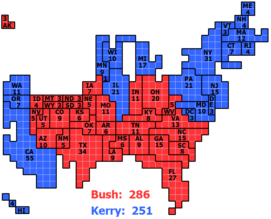
| Описание | Cartogram of 2004 Electoral Vote for US President, with each square representing one electoral vote. The population density of the 50 states varies by three orders of magnitude (from NJ with nearly 1,200 people per square mile, to AK with roughly 1 1/4 people per sq mi). Because of that huge variation, a regular map of the US that is typically used to present electoral vote results can convey a very skewed impression of the outcome where sparsely populated states appear overrepresented and densely populated states appear underrepresented. The cartogram approach of this image eliminates that problem by presenting the area of each state in an exact one-to-one correspondence with its number of electoral votes. But this is achieved at the cost of introducing distortions to the actual shape of each state and their positioning in relation to each other. |
|---|---|
| Источник | Own work |
| Время создания | 2008-09-06 |
| Автор или правообладатель | ChrisnHouston — Лицензия: CC BY-SA 3.0 (Creative Commons Attribution-Share Alike 3.0) http://creativecommons.org/licenses/by-sa/3.0/ |
| Другие версии файла | — |
Источник файла — сайт Wikimedia Commons, куда он был загружен под одной из свободных лицензий ( https://commons.wikimedia.org/wiki/File:Cartogram-2004_Electoral_Vote.gif ). Авторов, работавших над этим файлом см. в истории файла: https://commons.wikimedia.org/w/index.php?title=File:Cartogram-2004_Electoral_Vote.gif&action=history
В общем случае в статьях энциклопедии Руниверсалис файлы используются в соответствии со статьёй 1274 Гражданского кодекса Российской Федерации.
История файла
Нажмите на дату/время, чтобы увидеть версию файла от того времени.
| Дата/время | Миниатюра | Размеры | Участник | Примечание | |
|---|---|---|---|---|---|
| текущий | 17:26, 25 сентября 2023 | | 874 × 704 (31 КБ) | Я, робот (обсуждение | вклад) | == Описание == {{Изображение | описание = Cartogram of 2004 Electoral Vote for US President, with each square representing one electoral vote.<br/><br/> The population density of the 50 states varies by three orders of magnitude (from NJ with nearly 1,200 people per square mile, to AK with roughly 1 1/4 people per sq mi). Because of that huge variation, a regular map of the US that is typically used to present electoral vote results can convey a very skewed impression of the outcome where s... |
Вы не можете перезаписать этот файл.
Использование файла
Следующий файл является дубликатом этого файла (подробности):
- Файл:Cartogram-2004 Electoral Vote.gif на Викискладе
Следующая страница использует этот файл: