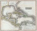
Файл:1814 Thomson Map of the West Indies ^ Central America - Geographicus - WestIndies-t-1814.jpg

Исходный файл (3000 × 2529 пкс, размер файла: 1,16 МБ, MIME-тип: image/jpeg)
Описание
| Описание | A masterpiece. This fascinating hand colored 1814 map by Edinburgh cartographer John Thomson depicts the West Indies and Central America. Covers from the Carolinas south through Texas, Mexico and central America to the northern part of South America as far as Venezuela and the Orinoco Delta. Includes all of the West Indies islands including the Caribbean and the Greater and Lesser Antilles. Extraordinarily details with notations on both physical and political features, as well as undersea elements, banks, and shoals. Notates several American Indian tribes in both North and South America. This map’s magnificent size, beautiful color, and high detail make this one of the finest maps of this region to appear in the early 19th century. |
|---|---|
| Источник | This file was provided to Wikimedia Commons by Geographicus Rare Antique Maps, a specialist dealer in rare maps and other cartography of the 15th, 16th, 17th, 18th and 19th centuries, as part of a cooperation project. |
| Время создания | 1814 |
| Автор или правообладатель | John Thomson
— Лицензия: Public domain (в общественном достоянии) |
| Другие версии файла | — |
Источник файла — сайт Wikimedia Commons, куда он был загружен под одной из свободных лицензий ( https://commons.wikimedia.org/wiki/File:1814_Thomson_Map_of_the_West_Indies_^_Central_America_-_Geographicus_-_WestIndies-t-1814.jpg ). Авторов, работавших над этим файлом см. в истории файла: https://commons.wikimedia.org/w/index.php?title=File:1814_Thomson_Map_of_the_West_Indies_^_Central_America_-_Geographicus_-_WestIndies-t-1814.jpg&action=history
В общем случае в статьях энциклопедии Руниверсалис файлы используются в соответствии со статьёй 1274 Гражданского кодекса Российской Федерации.
История файла
Нажмите на дату/время, чтобы увидеть версию файла от того времени.
| Дата/время | Миниатюра | Размеры | Участник | Примечание | |
|---|---|---|---|---|---|
| текущий | 14:54, 5 сентября 2023 |  | 3000 × 2529 (1,16 МБ) | Я, робот (обсуждение | вклад) | == Описание == {{Изображение | описание = A masterpiece. This fascinating hand colored 1814 map by Edinburgh cartographer John Thomson depicts the West Indies and Central America. Covers from the Carolinas south through Texas, Mexico and central America to the northern part of South America as far as Venezuela and the Orinoco Delta. Includes all of the West Indies islands including the Caribbean and the Greater and Lesser Antilles. Extraordinarily details with notations on both physical a... |
Вы не можете перезаписать этот файл.
Использование файла
Следующая страница использует этот файл: