


Файл:Shameen Canton.jpg
Размер этого предпросмотра: 800 × 375 пкс. Другое разрешение: 3840 × 1800 пкс.

Исходный файл (3840 × 1800 пкс, размер файла: 1,88 МБ, MIME-тип: image/jpeg)
Описание
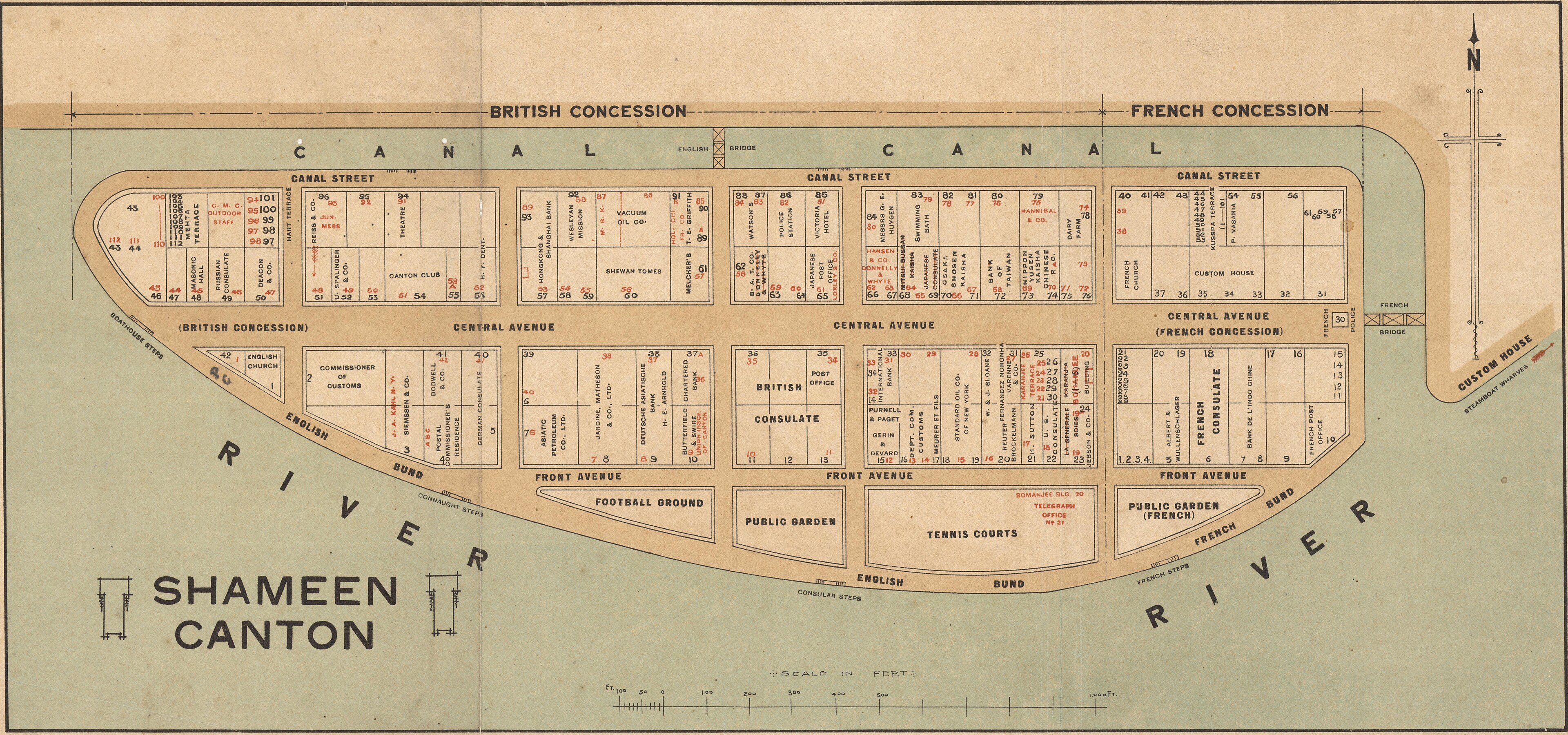
| Описание | Cadastral map of Shameen [i.e. Shamian Island] in Canton [i.e. Guangzhou]. It is one mile in circumference and lies just off Canton, which has always been a center of commerce, competing with Hong Kong, only sixty miles away. Because the island was a British and French Concession, it was carefully patrolled and connected to the mainland on the northern side by the carefully-guarded "English Bridge" and a French Bridge on the eastern side. The larger western part was English and the eastern part French. Each had its own municipal offices, even its own police forces, Sikhs for the British, Annamites for the French. The map shows in detail the use of the offices and buildings on the island. |
|---|---|
| Источник | http://nla.gov.au/nla.map-brsc67 |
| Время создания | between 1920 and 1929 |
| Автор или правообладатель | Unknown author — Лицензия: Public domain (в общественном достоянии) |
| Другие версии файла | — |
Источник файла — сайт Wikimedia Commons, куда он был загружен под одной из свободных лицензий ( https://commons.wikimedia.org/wiki/File:Shameen_Canton.jpg ). Авторов, работавших над этим файлом см. в истории файла: https://commons.wikimedia.org/w/index.php?title=File:Shameen_Canton.jpg&action=history


В общем случае в статьях энциклопедии Руниверсалис файлы используются в соответствии со статьёй 1274 Гражданского кодекса Российской Федерации.
История файла
Нажмите на дату/время, чтобы увидеть версию файла от того времени.
| Дата/время | Миниатюра | Размеры | Участник | Примечание | |
|---|---|---|---|---|---|
| текущий | 18:39, 1 мая 2026 | | 3840 × 1800 (1,88 МБ) | Я, робот (обсуждение | вклад) |
Вы не можете перезаписать этот файл.
Использование файла
Следующая страница использует этот файл:
