


Файл:PIA16189 fig1-Curiosity Rover-Rock Outcrops-Mars and Earth.jpg

Исходный файл (959 × 717 пкс, размер файла: 681 КБ, MIME-тип: image/jpeg)
Описание
| Описание | 09.26.2012
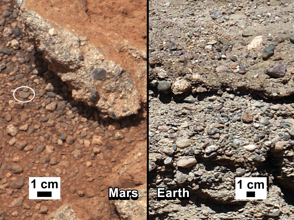
Rock Outcrops on Mars and Earth This set of images compares the Link outcrop of rocks on Mars (left) with similar rocks seen on Earth (right). The image of Link, obtained by NASA's Curiosity rover, shows rounded gravel fragments, or clasts, up to a couple inches (few centimeters), within the rock outcrop. Erosion of the outcrop results in gravel clasts that fall onto the ground, creating the gravel pile at left. The outcrop characteristics are consistent with a sedimentary conglomerate, or a rock that was formed by the deposition of water and is composed of many smaller rounded rocks cemented together. A typical Earth example of sedimentary conglomerate formed of gravel fragments in a stream is shown on the right. An annotated version of the image highlights a piece of gravel that is about 0.4 inches (1 centimeter) across. It was selected as an example of coarse size and rounded shape. Rounded grains (of any size) occur by abrasion in sediment transport, by wind or water, when the grains bounce against each other. Gravel fragments are too large to be transported by wind. At this size, scientists know the rounding occurred in water transport in a stream. The name Link is derived from a significant rock formation in the Northwest Territories of Canada, where there is also a lake with the same name. Scientists enhanced the color in the Mars image to show the scene as it would appear under the lighting conditions we have on Earth, which helps in analyzing the terrain. The Link outcrop was imaged with the 100-millimeter Mast Camera on Sept. 2, 2012, which was the 27th sol, or Martian day of operations. |
|---|---|
| Источник | http://photojournal.jpl.nasa.gov/figures/PIA16189_fig1.jpg |
| Время создания | 2012-09-25 14:50:18 |
| Автор или правообладатель | NASA/JPL-Caltech/MSSS and PSI — Лицензия: Public domain (в общественном достоянии) |
| Другие версии файла | — |

Источник файла — сайт Wikimedia Commons, куда он был загружен под одной из свободных лицензий ( https://commons.wikimedia.org/wiki/File:PIA16189_fig1-Curiosity_Rover-Rock_Outcrops-Mars_and_Earth.jpg ). Авторов, работавших над этим файлом см. в истории файла: https://commons.wikimedia.org/w/index.php?title=File:PIA16189_fig1-Curiosity_Rover-Rock_Outcrops-Mars_and_Earth.jpg&action=history


В общем случае в статьях энциклопедии Руниверсалис файлы используются в соответствии со статьёй 1274 Гражданского кодекса Российской Федерации.
История файла
Нажмите на дату/время, чтобы увидеть версию файла от того времени.
| Дата/время | Миниатюра | Размеры | Участник | Примечание | |
|---|---|---|---|---|---|
| текущий | 20:18, 15 декабря 2023 | | 959 × 717 (681 КБ) | I, Robot (обсуждение | вклад) | == Описание == {{Изображение | описание = 09.26.2012 <p>Rock Outcrops on Mars and Earth This set of images compares the Link outcrop of rocks on Mars (left) with similar rocks seen on Earth (right). The image of Link, obtained by NASA's Curiosity rover, shows rounded gravel fragments, or clasts, up to a couple inches (few centimeters), within the rock outcrop. Erosion of the outcrop results in gravel clasts that fall onto the ground, creating the gravel pile at left. The outcrop characterist... |
Вы не можете перезаписать этот файл.
Использование файла
Следующий файл является дубликатом этого файла (подробности):

- Файл:PIA16189 fig1-Curiosity Rover-Rock Outcrops-Mars and Earth.jpg на общем хранилище
Следующая страница использует этот файл:
