


Файл:PIA16157-MarsCuriosityRover-GoulburnLinkHottah-20120927.jpg

Исходный файл (932 × 720 пкс, размер файла: 129 КБ, MIME-тип: image/jpeg)
Описание
| Описание | 09.27.2012
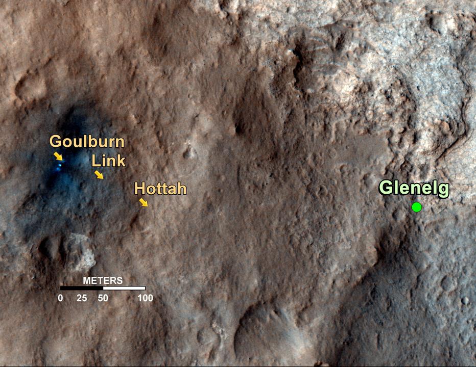
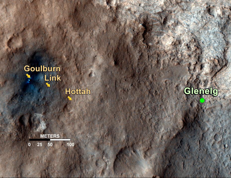
Curiosity's Roadside Discoveries This map shows the path on Mars of NASA's Curiosity rover toward Glenelg, an area where three terrains of scientific interest converge. Arrows mark geological features encountered so far that led to the discovery of what appears to be an ancient Martian streambed. The first site, dubbed Goulburn, is an area where the thrusters from the rover's descent stage blasted away a layer of loose material, exposing bedrock underneath. Goulburn gave scientists a hint that water might have transported the pebbly sandstone material making up the outcrop. The second feature, a naturally exposed rock outcrop named Link, stood out to the science team for its embedded, rounded gravel pieces. Such rounded shapes are strong evidence of water transport. The final feature, another naturally exposed rock outcrop named Hottah, offered the most compelling evidence yet of an ancient stream, as it contains abundant rounded pebbles. The grain sizes are also an important part of the evidence for water: the rounded pebbles, which are up to 1.6 inches (4 centimeters) in size, are too large to have been transported by wind. The image used for the map is from an observation of the landing site by the High Resolution Imaging Science Experiment (HiRISE) instrument on NASA's Mars Reconnaissance Orbiter. |
|---|---|
| Источник | http://photojournal.jpl.nasa.gov/jpeg/PIA16157.jpg |
| Время создания | 2012-10-05 13:30:29 |
| Автор или правообладатель | NASA/JPL-Caltech/Univ. of Arizona — Лицензия: Public domain (в общественном достоянии) |
| Другие версии файла | — |
Источник файла — сайт Wikimedia Commons, куда он был загружен под одной из свободных лицензий ( https://commons.wikimedia.org/wiki/File:PIA16157-MarsCuriosityRover-GoulburnLinkHottah-20120927.jpg ). Авторов, работавших над этим файлом см. в истории файла: https://commons.wikimedia.org/w/index.php?title=File:PIA16157-MarsCuriosityRover-GoulburnLinkHottah-20120927.jpg&action=history


В общем случае в статьях энциклопедии Руниверсалис файлы используются в соответствии со статьёй 1274 Гражданского кодекса Российской Федерации.
История файла
Нажмите на дату/время, чтобы увидеть версию файла от того времени.
| Дата/время | Миниатюра | Размеры | Участник | Примечание | |
|---|---|---|---|---|---|
| текущий | 13:18, 13 августа 2023 | | 932 × 720 (129 КБ) | I, Robot (обсуждение | вклад) | == Описание == {{Изображение | описание = 09.27.2012 <p>Curiosity's Roadside Discoveries This map shows the path on Mars of NASA's Curiosity rover toward Glenelg, an area where three terrains of scientific interest converge. Arrows mark geological features encountered so far that led to the discovery of what appears to be an ancient Martian streambed. The first site, dubbed Goulburn, is an area where the thrusters from the rover's descent stage blasted away a layer of loose material, exposin... |
Вы не можете перезаписать этот файл.
Использование файла
Следующий файл является дубликатом этого файла (подробности):

- Файл:PIA16157-MarsCuriosityRover-GoulburnLinkHottah-20120927.jpg на общем хранилище
Следующие 3 страницы используют этот файл:
