


Файл:Nares strait border (Kennedy channel).png

Исходный файл (1765 × 1249 пкс, размер файла: 124 КБ, MIME-тип: image/png)
Описание
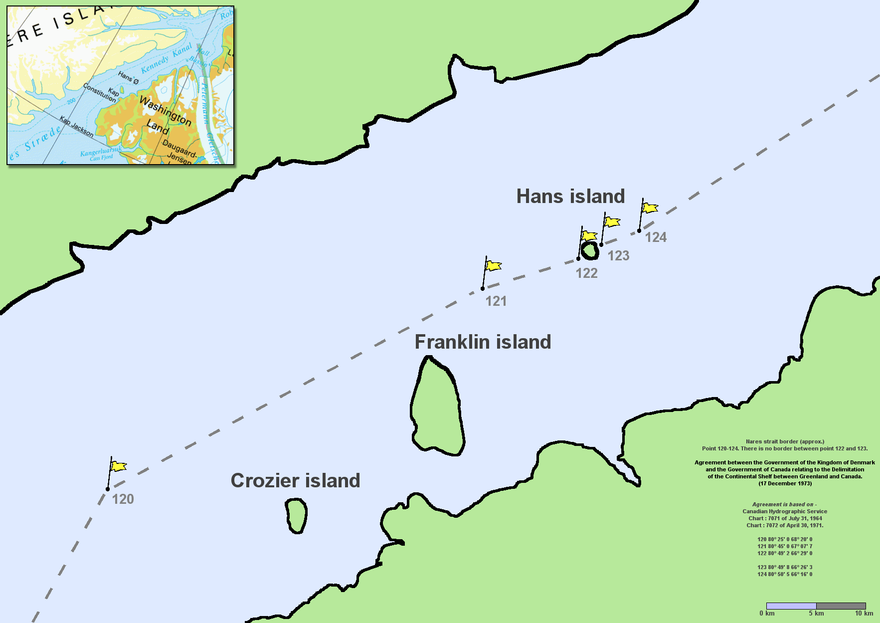
| Описание | en:Nares Strait (en:Kennedy Channel) border (approx.) Point 120–124. There is no border between point 122 and 123. Agreement between the Government of the Kingdom of Denmark and the Government of Canada relating to the Delimitation of the Continental Shelf between Greenland and Canada. (17 December 1973) Agreement is based on en:Canadian Hydrographic Service charts 7071 of July 31, 1964 and 7072 of April 30, 1971
By Lasse Jensen, July 29, 2005 |
|---|---|
| Источник | <style data-mw-deduplicate="TemplateStyles:r666199556">.mw-parser-output .responsive-license-cc{clear:both;text-align:center;box-sizing:border-box;width:100%;justify-content:space-around;align-items:center;margin:0.5em auto;background-color:#f9f9f9;border:2px solid #e0e0e0;border-spacing:8px;display:flex}.mw-parser-output .responsive-license-cc div{margin:4px}.mw-parser-output .rlicense-text div{margin:0.5em auto}@media screen and (max-width:640px){.mw-parser-output .responsive-license-cc{flex-flow:column}.mw-parser-output .rlicense-text{order:1 |
| Время создания | |
| Автор или правообладатель | |
| Другие версии файла | — |
</style>


- You are free:
- to share – to copy, distribute and transmit the work
- to remix – to adapt the work
- Under the following conditions:
- attribution – You must give appropriate credit, provide a link to the license, and indicate if changes were made. You may do so in any reasonable manner, but not in any way that suggests the licensor endorses you or your use.
| время создания = Commons upload by File Upload Bot (Magnus Manske) 10:54, 7 June 2006 (UTC) | автор = User Twthmoses on en.wikipedia — Лицензия: CC BY 2.5 (Creative Commons Attribution 2.5) https://creativecommons.org/licenses/by/2.5 }} Источник файла — сайт Wikimedia Commons, куда он был загружен под одной из свободных лицензий ( https://commons.wikimedia.org/wiki/File:Nares_strait_border_(Kennedy_channel).png ). Авторов, работавших над этим файлом см. в истории файла: https://commons.wikimedia.org/w/index.php?title=File:Nares_strait_border_(Kennedy_channel).png&action=history
.png)
.png&action=history)
В общем случае в статьях энциклопедии Руниверсалис файлы используются в соответствии со статьёй 1274 Гражданского кодекса Российской Федерации.
История файла
Нажмите на дату/время, чтобы увидеть версию файла от того времени.
| Дата/время | Миниатюра | Размеры | Участник | Примечание | |
|---|---|---|---|---|---|
| текущий | 12:35, 16 августа 2023 | | 1765 × 1249 (124 КБ) | Я, робот (обсуждение | вклад) | == Описание == {{Изображение | описание = <p>[https://en.wikipedia.org/wiki/Nares_Strait en:Nares Strait] ([https://en.wikipedia.org/wiki/Kennedy_Channel en:Kennedy Channel]) border (approx.) Point 120–124. There is no border between point 122 and 123. </p><p><i>Agreement between the Government of the Kingdom of Denmark and the Government of Canada relating to the Delimitation of the Continental Shelf between Greenland and Canada. (17 December 1973)</i> </p><p><i>Agreement is based on</i> [h... |
Вы не можете перезаписать этот файл.
Использование файла
Следующий файл является дубликатом этого файла (подробности):
.png)
- Файл:Nares strait border (Kennedy channel).png на общем хранилище
Следующие 2 страницы используют этот файл:
.png&oldid=16683079)