

Файл:Map of Salta-Antofagasta Railway.png

Исходный файл (846 × 438 пкс, размер файла: 68 КБ, MIME-тип: image/png)
Описание
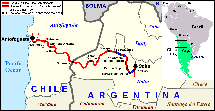
| Описание | Railway map of the Salta–Antofagasta line (Huaytiquina) within Argentina and Chile. Red line with blue dashes represents the route of the Tren a las Nubes. The names of Chilean regions and Argentine provinces (in blue the ones served by the line) are shown in the map. On the right corner, a map of South America highlighting Argentina and Chile, shows the line (the little blue strip) within the continent. |
|---|---|
| Источник | The geographical maps of Argentina, Chile and South America are derived work from the files Argentina location map.svg (by NordNordWest), Chile loc map.svg (by Gvf) and Blank-South-America-map.png (by Rydia) |
| Время создания | 2012-04-07 |
| Автор или правообладатель | Dэя-Бøяg — Лицензия: CC BY-SA 3.0 (Creative Commons Attribution-Share Alike 3.0) http://creativecommons.org/licenses/by-sa/3.0/ |
| Другие версии файла | — |


Источник файла — сайт Wikimedia Commons, куда он был загружен под одной из свободных лицензий ( https://commons.wikimedia.org/wiki/File:Map_of_Salta-Antofagasta_Railway.png ). Авторов, работавших над этим файлом см. в истории файла: https://commons.wikimedia.org/w/index.php?title=File:Map_of_Salta-Antofagasta_Railway.png&action=history


В общем случае в статьях энциклопедии Руниверсалис файлы используются в соответствии со статьёй 1274 Гражданского кодекса Российской Федерации.
История файла
Нажмите на дату/время, чтобы увидеть версию файла от того времени.
| Дата/время | Миниатюра | Размеры | Участник | Примечание | |
|---|---|---|---|---|---|
| текущий | 09:36, 15 августа 2023 | | 846 × 438 (68 КБ) | Я, робот (обсуждение | вклад) | == Описание == {{Изображение | описание = Railway map of the [https://en.wikipedia.org/wiki/Salta%E2%80%93Antofagasta_railway Salta–Antofagasta line] (Huaytiquina) within Argentina and Chile. Red line with blue dashes represents the route of the <i>[https://en.wikipedia.org/wiki/Tren_a_las_Nubes Tren a las Nubes]</i>. The names of Chilean regions and Argentine provinces (in blue the ones served by the line) are shown in the map. On the right corner, a map of South America highlighting Argent... |
Вы не можете перезаписать этот файл.
Использование файла
Следующий файл является дубликатом этого файла (подробности):

- Файл:Map of Salta-Antofagasta Railway.png на общем хранилище
Следующие 2 страницы используют этот файл:
