


Файл:Grimancreekmap.jpg
Размер этого предпросмотра: 717 × 599 пкс. Другое разрешение: 1200 × 1003 пкс.

Исходный файл (1200 × 1003 пкс, размер файла: 268 КБ, MIME-тип: image/jpeg)
Описание
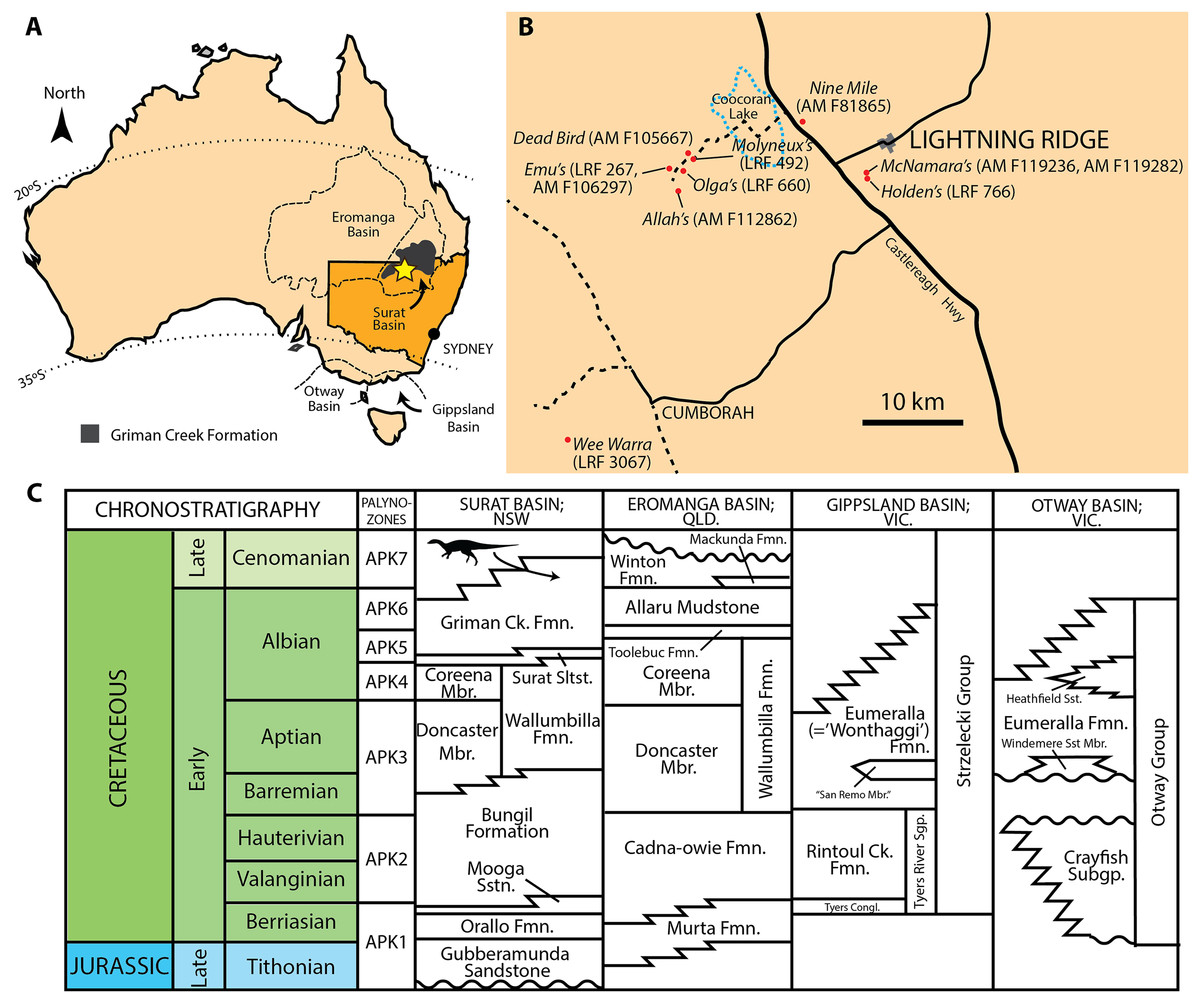
| Описание | (A) Present day map of Australia with the town of Lightning Ridge indicated by the star. (B) Regional map of the Lightning Ridge region showing localities (where known) for specimens described in this text. Sealed (solid black lines) and unsealed roads (dashed lines) are indicated. The ephemeral Coocoran Lake is marked with a dotted blue line. (C) Correlative stratigraphy of the major Cretaceous depositional basins and geological units discussed in this study. The ornithopod icon and arrow indicate the approximate level of the Griman Creek Formation from which the current material pertains. Informal units are in quotation marks. Maps in (A) and (B) redrawn and modified from Bell et al. (2016) and Opal Fields—Lightning Ridge Region map produced by the NSW Department of Mineral Resources, respectively. Stratigraphy based on Toslini, McLoughlin & Drinnan (1999) and Cook, Bryan & Draper (2013). Ornithopod silhouette created by Caleb M. Brown and used under the Creative Commons Attribution-ShareAlike 3.0 Unported license. |
|---|---|
| Источник | https://peerj.com/articles/6008/ |
| Время создания | 2018-12-04 |
| Автор или правообладатель | Phil R. Bell, Matthew C. Herne, Tom Brougham, Elizabeth T. Smith — Лицензия: CC BY 4.0 (Creative Commons Attribution 4.0) https://creativecommons.org/licenses/by/4.0 |
| Другие версии файла | — |
Источник файла — сайт Wikimedia Commons, куда он был загружен под одной из свободных лицензий ( https://commons.wikimedia.org/wiki/File:Grimancreekmap.jpg ). Авторов, работавших над этим файлом см. в истории файла: https://commons.wikimedia.org/w/index.php?title=File:Grimancreekmap.jpg&action=history


В общем случае в статьях энциклопедии Руниверсалис файлы используются в соответствии со статьёй 1274 Гражданского кодекса Российской Федерации.
История файла
Нажмите на дату/время, чтобы увидеть версию файла от того времени.
| Дата/время | Миниатюра | Размеры | Участник | Примечание | |
|---|---|---|---|---|---|
| текущий | 12:12, 12 августа 2025 | | 1200 × 1003 (268 КБ) | SubBot (обсуждение | вклад) | == Описание == {{Изображение | описание = (A) Present day map of Australia with the town of Lightning Ridge indicated by the star. (B) Regional map of the Lightning Ridge region showing localities (where known) for specimens described in this text. Sealed (solid black lines) and unsealed roads (dashed lines) are indicated. The ephemeral Coocoran Lake is marked with a dotted blue line. (C) Correlative stratigraphy of the major Cretaceous depositional basins and geological units discussed in t... |
Вы не можете перезаписать этот файл.
Использование файла
Следующий файл является дубликатом этого файла (подробности):

- Файл:Grimancreekmap.jpg на общем хранилище
Следующая страница использует этот файл:
