


Файл:Early-Historical-Israel-Dan-Beersheba-Judea.png

Исходный файл (860 × 1210 пкс, размер файла: 58 КБ, MIME-тип: image/png)
Описание
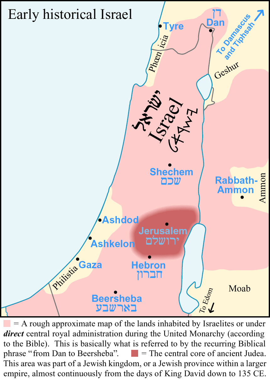
| Описание | In this graphic about early historical Israel, the pink area is a rough approximate map of the near-maximum boundaries of the lands that were inhabited by Israelites or under direct central royal administration during the United Monarchy period of ancient history (according to the Bible) -- excluding states (such as Damascus, Geshur, Ammon, Moab, Edom, and the Philistine city-states) which sometimes acknowledged some degree of Israelite suzerainty or overlordship, but were never integral or directly-administered parts of the unified Israelite kingdom of David or Solomon. This is basically what is referred to by the Biblical phrase "from Dan to Beersheba" (which occurs nine times in the Hebrew Bible / Old Testament -- at Judges 20:1, 1 Samuel 3:20, 2 Samuel 3:10, 2 Samuel 17:11, 2 Samuel 24:2, 2 Samuel 24:15, 1 Kings 4:25, 1 Chronicles 21:2, and 2 Chronicles 30:5). So the passage 1 Kings 4:24-25 (1 Kings 5:4-5 in Jewish verse numbering) describes Solomon's larger empire with the phrase "from Tiphsah to Gaza", these being the northeasternmost and southwesternmost noteworthy cities that recognized some allegiance to Solomon (Tiphsah was a trade outpost in northern Syria, at the bend in the Upper Euphrates) — but the actual land "where Judah and Israel dwelt in safety" was described as being "from Dan to Beersheba". The dark red area in the graphic shows the central core of ancient Judea. This area (more or less the southern half of the west bank hill-chain, roughly from Ramallah to Hebron or slightly north of Hebron) was almost always part of a Jewish kingdom or a Jewish province within a larger empire for over a thousand years, from the days of King David down to 135 CE. The only cities shown on the map were capital cities, or were important landmarks in demarcating ancient Israel or Judea. The areas to the immediate south and east of the map frame were more sparsely inhabited, with a lower proportion of settled agriculture, so that boundaries were rather indefinite there. The borders of the 1923-1947 British mandate territory (i.e. the modern Israel + West Bank + Gaza) are shown in grey. |
|---|---|
| Источник | Own work based on visual inspection (not scanning) of a variety of sources, the single most important source probably being the Administrative Districts of Solomon's Kingdom Map, map no. 113 on page 86 of the MacMillan Bible Atlas (3rd edition, 1993) by Yohanan Aharoni, Michael Avi-Yonah, Anson F. Rainey, and Ze'ev Safrai ISBN 0025006053 (and to a lesser degree the Kingdom of David Map, map no. 104 on page 80). For a published map showing an outline similar to the light pink on this map, see the "Israel in the Time of David" map on page 222 of The Atlas of World History (second edition, 2005; general editor Jeremy Black) ISBN 978-0-7566-5348-4 (not seen by me when I made this image). |
| Время создания | 2005-09 |
| Автор или правообладатель | AnonMoos — Лицензия: Public domain (в общественном достоянии) |
| Другие версии файла | — |
Источник файла — сайт Wikimedia Commons, куда он был загружен под одной из свободных лицензий ( https://commons.wikimedia.org/wiki/File:Early-Historical-Israel-Dan-Beersheba-Judea.png ). Авторов, работавших над этим файлом см. в истории файла: https://commons.wikimedia.org/w/index.php?title=File:Early-Historical-Israel-Dan-Beersheba-Judea.png&action=history


В общем случае в статьях энциклопедии Руниверсалис файлы используются в соответствии со статьёй 1274 Гражданского кодекса Российской Федерации.
История файла
Нажмите на дату/время, чтобы увидеть версию файла от того времени.
| Дата/время | Миниатюра | Размеры | Участник | Примечание | |
|---|---|---|---|---|---|
| текущий | 03:23, 10 октября 2023 | | 860 × 1210 (58 КБ) | Я, робот (обсуждение | вклад) | == Описание == {{Изображение | описание = <p>In this graphic about early historical Israel, the pink area is a rough approximate map of the near-maximum boundaries of the lands that were inhabited by Israelites or under <i><b>direct</b></i> central royal administration during the United Monarchy period of ancient history (according to the Bible) -- excluding states (such as Damascus, Geshur, Ammon, Moab, Edom, and the Philistine city-states) which sometimes acknowledged some degree of Israel... |
Вы не можете перезаписать этот файл.
Использование файла
Следующий файл является дубликатом этого файла (подробности):

- Файл:Early-Historical-Israel-Dan-Beersheba-Judea.png на общем хранилище
Следующая страница использует этот файл:
