


Файл:Dominion of Pakistan & Indian Controlled Kashmir (orthographic projection).svg


Исходный файл (SVG-файл, номинально 541 × 541 пкс, размер файла: 396 КБ)
Описание
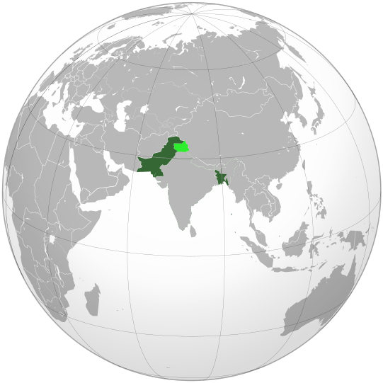
| Описание | Dominion of Pakistan is highlighted in dark green and Indian Controlled Kashmir in light green. This map shows the borders of every countries, political entities and other territories between July 2006 to June 2011, which makes a big mistake. Here is the reason: Dominion of Pakistan existed from 14 August 1947, when it became independent from British India, to 23 March 1956, when it was succeeded by Islamic Republic of Pakistan. Thus, this map should show the borders of every countries, political entities, colonies and other territories at the end of 1955 (see the English Wikipedia articles "List of sovereign states in 1955" and "List of national border changes since World War I"). |
|---|---|
| Источник | Own work |
| Время создания | Sunday 31 May 2009 (01:06 GMT+1) |
| Автор или правообладатель | SelfQ — Лицензия: CC BY-SA 3.0 (Creative Commons Attribution-Share Alike 3.0) https://creativecommons.org/licenses/by-sa/3.0 |
| Другие версии файла | — |
Источник файла — сайт Wikimedia Commons, куда он был загружен под одной из свободных лицензий ( https://commons.wikimedia.org/wiki/File:Dominion_of_Pakistan_&_Indian_Controlled_Kashmir_(orthographic_projection).svg ). Авторов, работавших над этим файлом см. в истории файла: https://commons.wikimedia.org/w/index.php?title=File:Dominion_of_Pakistan_&_Indian_Controlled_Kashmir_(orthographic_projection).svg&action=history
.svg)
.svg&action=history)
В общем случае в статьях энциклопедии Руниверсалис файлы используются в соответствии со статьёй 1274 Гражданского кодекса Российской Федерации.
История файла
Нажмите на дату/время, чтобы увидеть версию файла от того времени.
| Дата/время | Миниатюра | Размеры | Участник | Примечание | |
|---|---|---|---|---|---|
| текущий | 17:33, 14 августа 2023 | | 541 × 541 (396 КБ) | I, Robot (обсуждение | вклад) | == Описание == {{Изображение | описание = Dominion of Pakistan is highlighted in dark green and Indian Controlled Kashmir in light green. This map shows the borders of every countries, political entities and other territories between July 2006 to June 2011, which makes a big mistake. Here is the reason: [https://en.m.wikipedia.org/wiki/Dominion_of_Pakistan Dominion of Pakistan] existed from 14 August 1947, when it became independent from [https://en.m.wikipedia.org/wiki/British_Raj British I... |
Вы не можете перезаписать этот файл.
Использование файла
Следующий файл является дубликатом этого файла (подробности):
.svg)
.svg)
Следующие 4 страницы используют этот файл:
- Доминион Пакистан
- Третья индо-пакистанская война
- Файл:Dominion of Pakistan (orthographic projection).svg (файловое перенаправление)
.svg&redirect=no)
.svg&oldid=16594638)