


Файл:Daedelus comparison, remote sensing in precision farming.jpg

Исходный файл (540 × 883 пкс, размер файла: 143 КБ, MIME-тип: image/jpeg)
Описание
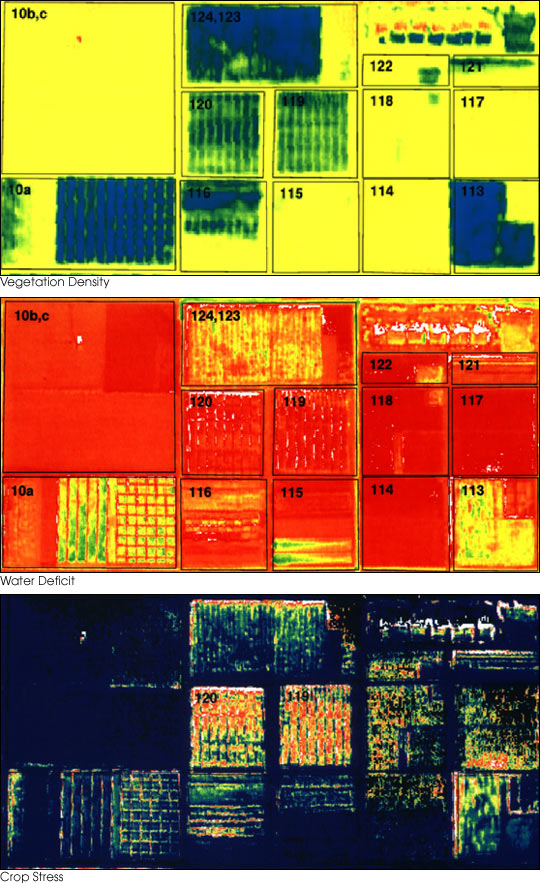
| Описание | These three false-color images demonstrate some of the applications of remote sensing in precision farming. The goal of precision farming is to improve farmers’ profits and harvest yields while reducing the negative impacts of farming on the environment that come from over-application of chemicals. The images were acquired by the Daedalus sensor aboard a NASA aircraft flying over the Maricopa Agricultural Center in Arizona.
See also Precision Farming (Feature Article on earthobservatory.nasa.gov). |
|---|---|
| Источник | earthobservatory.nasa.gov (NASA Earth Observatory, Image of the Day 2001-01-30 "Precision Farming") |
| Время создания | before 30 January 2001 |
| Автор или правообладатель | Susan Moran, Landsat 7 Science Team and USDA Agricultural Research Service (U.S. Government work) — Лицензия: Public domain (в общественном достоянии) |
| Другие версии файла | — |
Источник файла — сайт Wikimedia Commons, куда он был загружен под одной из свободных лицензий ( https://commons.wikimedia.org/wiki/File:Daedelus_comparison,_remote_sensing_in_precision_farming.jpg ). Авторов, работавших над этим файлом см. в истории файла: https://commons.wikimedia.org/w/index.php?title=File:Daedelus_comparison,_remote_sensing_in_precision_farming.jpg&action=history


В общем случае в статьях энциклопедии Руниверсалис файлы используются в соответствии со статьёй 1274 Гражданского кодекса Российской Федерации.
История файла
Нажмите на дату/время, чтобы увидеть версию файла от того времени.
| Дата/время | Миниатюра | Размеры | Участник | Примечание | |
|---|---|---|---|---|---|
| текущий | 21:06, 5 октября 2023 | | 540 × 883 (143 КБ) | Я, робот (обсуждение | вклад) | == Описание == {{Изображение | описание = These three false-color images demonstrate some of the applications of remote sensing in [https://en.wikipedia.org/wiki/Precision_agriculture precision farming]. The goal of precision farming is to improve farmers’ profits and harvest yields while reducing the negative impacts of farming on the environment that come from over-application of chemicals. The images were acquired by the Daedalus sensor aboard a NASA aircraft flying over the Maricopa Agri... |
Вы не можете перезаписать этот файл.
Использование файла
Следующий файл является дубликатом этого файла (подробности):

- Файл:Daedelus comparison, remote sensing in precision farming.jpg на общем хранилище
Следующая страница использует этот файл:
