


Файл:Canada provinces 1867-1870.png

Исходный файл (1000 × 864 пкс, размер файла: 61 КБ, MIME-тип: image/png)
Описание
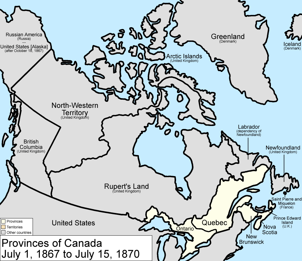
| Описание | Map of the provinces of Canada as they were from 1867 to 1870. On July 2 1867, the Dominion of Canada was created from three provinces of British North America: Canada (split into the provinces of Ontario and Quebec), New Brunswick, and Nova Scotia. On July 14 1870, Rupert's Land and the North-Western Territories were ceded to Canada, and became the North-West Territories; a small square of this was made the province of Manitoba. Note that, to make for simpler mapping, the western and southwestern portions of the 1927 Privy Council "Coast of Labrador" boundary is used. For the southern boundary, from River Romaine east, Quebec's version of the boundary is used. Until 1927, Canada recognized only a tiny sliver along the Atlantic Ocean as belonging to Washington. Made by User:Golbez. |
|---|---|
| Источник | No machine-readable source provided. Own work assumed (based on copyright claims). |
| Время создания | 13 February 2006 (original upload date) |
| Автор или правообладатель | No machine-readable author provided. Golbez assumed (based on copyright claims). — Лицензия: CC BY 2.5 (Creative Commons Attribution 2.5) https://creativecommons.org/licenses/by/2.5 |
| Другие версии файла | — |
Источник файла — сайт Wikimedia Commons, куда он был загружен под одной из свободных лицензий ( https://commons.wikimedia.org/wiki/File:Canada_provinces_1867-1870.png ). Авторов, работавших над этим файлом см. в истории файла: https://commons.wikimedia.org/w/index.php?title=File:Canada_provinces_1867-1870.png&action=history


В общем случае в статьях энциклопедии Руниверсалис файлы используются в соответствии со статьёй 1274 Гражданского кодекса Российской Федерации.
История файла
Нажмите на дату/время, чтобы увидеть версию файла от того времени.
| Дата/время | Миниатюра | Размеры | Участник | Примечание | |
|---|---|---|---|---|---|
| текущий | 14:00, 6 августа 2023 | | 1000 × 864 (61 КБ) | I, Robot (обсуждение | вклад) | == Описание == {{Изображение | описание = <p>Map of the provinces of Canada as they were from 1867 to 1870. On July 2 1867, the Dominion of Canada was created from three provinces of British North America: Canada (split into the provinces of Ontario and Quebec), New Brunswick, and Nova Scotia. On July 14 1870, Rupert's Land and the North-Western Territories were ceded to Canada, and became the North-West Territories; a small square of this was made the province of Manitoba. Note that, to mak... |
Вы не можете перезаписать этот файл.
Использование файла
Следующий файл является дубликатом этого файла (подробности):

- Файл:Canada provinces 1867-1870.png на общем хранилище
Следующие 3 страницы используют этот файл:
