


Файл:6308-AnaheimDisneyLand-NW to SE View.jpg

Исходный файл (1802 × 1110 пкс, размер файла: 2,35 МБ, MIME-тип: image/jpeg)
Описание
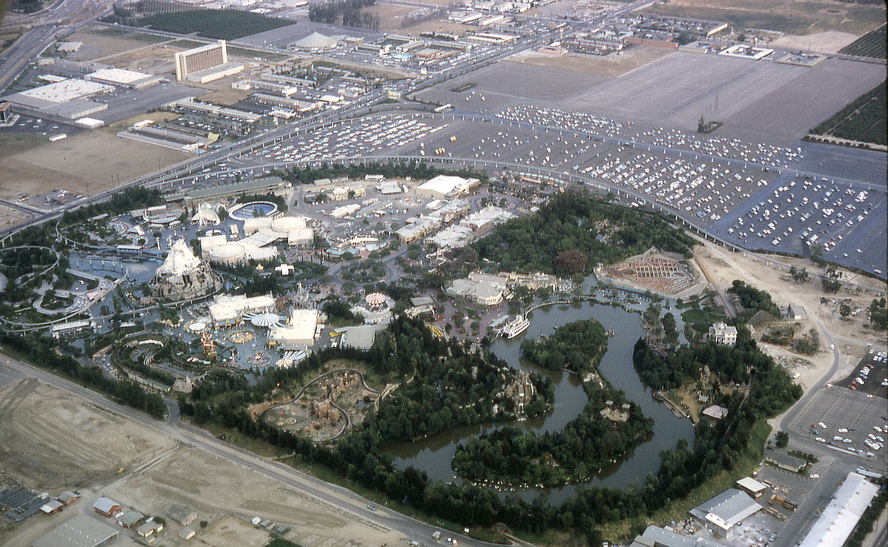
| Описание | Aerial view of Disneyland looking southeast in 1963, located in Anaheim, California, United States. The Santa Ana Freeway (I-5) is in the upper left corner. Harbor Boulevard forms the eastern boundary of the park. To the middle right, one can see the Haunted Mansion under construction. While the main building is complete on the outside (the white building), the show building is just beginning construction on the right side of the railroad tracks (most of the ride takes place in a show building outside the confines of the railroad). The Haunted Mansion would open in 1969. Also under construction, and up and left from the Haunted Mansion, is Pirates of the Caribbean, which opened in 1967. The two attractions took a while to build because Disney's engineering arm at the time, WED Enterprises (now known as Walt Disney Imagineering), was busy on projects dealing with the 1964 New York World's Fair. Both attractions are located in New Orleans Square, which opened in 1966. Anaheim's newly completed Melodyland Theater ("theater-in-the-round"), is at the top of the photo. |
|---|---|
| Источник | Own work |
| Время создания | 1963-08 |
| Автор или правообладатель | Robert J. Boser (EditorASC) — Лицензия: CC BY 3.0 (Creative Commons Attribution 3.0) https://creativecommons.org/licenses/by/3.0 |
| Другие версии файла | — |
Источник файла — сайт Wikimedia Commons, куда он был загружен под одной из свободных лицензий ( https://commons.wikimedia.org/wiki/File:6308-AnaheimDisneyLand-NW_to_SE_View.jpg ). Авторов, работавших над этим файлом см. в истории файла: https://commons.wikimedia.org/w/index.php?title=File:6308-AnaheimDisneyLand-NW_to_SE_View.jpg&action=history


В общем случае в статьях энциклопедии Руниверсалис файлы используются в соответствии со статьёй 1274 Гражданского кодекса Российской Федерации.
История файла
Нажмите на дату/время, чтобы увидеть версию файла от того времени.
| Дата/время | Миниатюра | Размеры | Участник | Примечание | |
|---|---|---|---|---|---|
| текущий | 10:36, 4 сентября 2023 | | 1802 × 1110 (2,35 МБ) | I, Robot (обсуждение | вклад) | == Описание == {{Изображение | описание = Aerial view of [https://en.wikipedia.org/wiki/Disneyland_Park_(Anaheim) Disneyland] looking southeast in 1963, located in [https://en.wikipedia.org/wiki/Anaheim Anaheim], [https://en.wikipedia.org/wiki/California California], [https://en.wikipedia.org/wiki/United_States United States]. The [https://en.wikipedia.org/wiki/Santa_Ana_Freeway Santa Ana Freeway (I-5)] is in the upper left corner. [https://en.wikipedia.org/wiki/Harbor_Boulevard Harbor Boule... |
Вы не можете перезаписать этот файл.
Использование файла
Следующий файл является дубликатом этого файла (подробности):

- Файл:6308-AnaheimDisneyLand-NW to SE View.jpg на общем хранилище
Следующая страница использует этот файл:
