Файл:Moon Farside LRO.jpg

Исходный файл (18 000 × 18 000 пкс, размер файла: 85,34 Мб, MIME-тип: image/jpeg)
| Внимание! | Изображение содержит очень большое количество пикселей, и при просмотре его в полном разрешении в некоторых обозревателях могут возникнуть такие проблемы, как загрузка искажённого изображения или зависание. |
|---|
Lower-resolution versions: 6000px, 3000px, and 1000px
Краткое описание
| Описание |
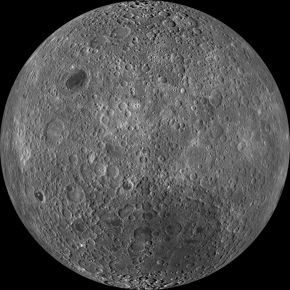
English: Far side of the moon, by NASA's Lunar Reconnaissance Orbiter. Orthographic projection centred at 180° longitude, 0° latitude.
Because the moon is tidally locked (meaning the same side always faces Earth), it was not until 1959 that the farside was first imaged by the Soviet Luna 3 spacecraft (hence the Russian names for prominent farside features, such as Mare Moscoviense). And what a surprise – unlike the widespread maria on the nearside, basaltic volcanism was restricted to a relatively few, smaller regions on the farside, and the battered highlands crust dominated. A different world from what we saw from Earth. Of course, the cause of the farside/nearside asymmetry is an interesting scientific question. Past studies have shown that the crust on the farside is thicker, likely making it more difficult for magmas to erupt on the surface, limiting the amount of farside mare basalts. Why is the farside crust thicker? That is still up for debate, and in fact several presentations at this week's Lunar and Planetary Science Conference attempt to answer this question. The Clementine mission obtained beautiful mosaics with the sun high in the sky (low phase angles), but did not have the opportunity to observe the farside at sun angles favorable for seeing surface topography. This WAC mosaic provides the most complete look at the morphology of the farside to date and will provide a valuable resource for the scientific community. And it's simply a spectacular sight! The Lunar Reconnaissance Orbiter Camera (LROC) Wide Angle Camera (WAC) is a push-frame camera that captures seven color bands (321, 360, 415, 566, 604, 643, and 689 nm) with a 57 km swath (105 km swath in monochrome mode) from a 50 km orbit. One of the primary objectives of LROC is to provide a global 100 m/px monochrome (643 nm) base map with incidence angles between 55° and 70° at the equator, lighting that is favorable for morphological interpretations. Each month, the WAC provides nearly complete coverage of the Moon under unique lighting. As an added bonus, the orbit-to-orbit image overlap provides stereo coverage. Reducing all these stereo images into a global topographic map is a big job, which is being led by LROC Team Members from the German Aerospace Center (Deutsches Zentrum für Luft- und Raumfahrt; DLR). Several preliminary WAC topographic products have appeared in LROC featured images over the past year (Orientale basin, Sinus Iridum). The WAC topographic dataset will be completed and released later this year. The global mosaic released today is comprised of over 15,000 WAC images acquired between November 2009 and February 2011. The non-polar images were map-projected onto the GLD100 shape model (WAC derived 100 m/px DTM), while polar images were map-projected on the LOLA shape model. In addition, the LOLA-derived crossover-corrected ephemeris and an improved camera pointing provide accurate positioning (better than 100 m) of each WAC image. |
| Дата | между ноябрём 2009 и февралём 2011 |
| Источник | http://wms.lroc.asu.edu/lroc_browse/view/WAC_GL180 (see also http://photojournal.jpl.nasa.gov/catalog/PIA14021) |
| Автор | NASA/GSFC/Arizona State University |
| Другие версии | Lower-resolution versions: 6000px, 3000px, and 1000px |
Это изображение или видеозапись внесены в каталог Лаборатории реактивного движения НАСА под идентификатором (Photo ID): PIA14021. Этот шаблон не указывает на правовой статус данной работы. По-прежнему необходим нормальный шаблон лицензий. См. Commons:Лицензирование. Другие языки:
|
Лицензирование
| Этот файл находится в общественном достоянии (англ. public domain), так как он был создан NASA (Национальным управлением по аэронавтике и исследованию космического пространства). Политика авторского права NASA гласит, что «Материал NASA не защищается авторским правом, если не указано иное». (См. Template:PD-USGov, страницу политики авторского права NASA или политику использования изображений JPL.) | ||
 |
Предупреждения:
|
| Аннотации | Это изображение аннотировано: Просмотреть аннотации на Викискладе |
История файла
Нажмите на дату/время, чтобы увидеть версию файла от того времени.
| Дата/время | Миниатюра | Размеры | Участник | Примечание | |
|---|---|---|---|---|---|
| текущий | 02:47, 20 марта 2014 | | 18 000 × 18 000 (85,34 Мб) | wikimediacommons>Huntster | High resolution mosaic. |
Использование файла
Следующая 81 страница использует этот файл:
- KREEP
- Lunar Mission One
- Аполлон (космическая программа)
- Артемида (космическая программа)
- Атмосфера Луны
- Бассейн Южный полюс — Эйткен
- Видимая сторона Луны
- Геология Луны
- Гипотетические естественные спутники Земли
- Голубая луна
- Гравитация Луны
- Долина Шрёдингера
- Иллюзия Луны
- Исследование Луны
- Колонизация Луны
- Космическое выветривание
- Кратковременные лунные явления
- Лазерная локация Луны
- Ложная луна
- Луна
- Луна в мифологии
- Лунная лавовая трубка
- Лунная ночь (время суток)
- Лунное затмение
- Лунное затмение 10 декабря 2011 года
- Лунное затмение 15 июня 2011 года
- Лунное затмение 1 марта 1504 года
- Лунное затмение 21 декабря 2010 года
- Лунное затмение 21 января 2019 года
- Лунное затмение 27 июля 2018 года
- Лунное затмение 28 сентября 2015 года
- Лунное затмение 31 января 2018 года
- Лунное затмение 4 июня 2012 года
- Лунное затмение 8 ноября 2022 года
- Лунное море
- Лунный автомобиль
- Лунный заговор
- Лунный календарь
- Лунный кратер
- Лунный метеорит
- Лунный пик
- Лунотрясение
- Лучевые системы на Луне
- Лёд на Луне
- Магнитное поле Луны
- Маскон
- Международная лунная станция
- Месяц
- Модель ударного формирования Луны
- Море Москвы
- Неомения
- Новолуние
- Обратная сторона Луны
- Орбита Луны
- Пепельный свет Луны
- Первая четверть
- Пик вечного света
- Поздняя тяжёлая бомбардировка
- Полнолуние
- Происхождение Луны
- Реголит
- Рилль
- Российская лунная программа
- Северный полюс Луны
- Селенография
- Селенохронологическая шкала
- Солнечное затмение
- Солнечное затмение на Луне
- Список борозд на Луне
- Список гор на Луне
- Список деталей рельефа Луны
- Список долин на Луне
- Список кратеров на Луне
- Суперлуние
- Талассоид
- Фазы Луны
- Циолковский (лунный кратер)
- Цирк (селенография)
- Энгельгардт (лунный кратер)
- Южный полюс Луны
- Шаблон:Луна