Файл:Greece in 1210.svg

Исходный файл (SVG-файл, номинально 3508 × 2000 пкс, размер файла: 1,12 Мб)
Описание
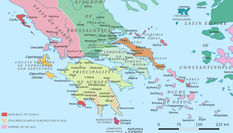
| Описание | Political map of southern Greece in c. 1210, after the establishment of the Crusader states following the Fourth Crusade. |
|---|---|
| Источник | SVG base from File:Greece in 1210V1.svg; based on the original political map by William Miller (1908), with changes and corrections to account for newer scholarship:
Any further suggestions for corrections or improvement are welcome. |
| Время создания | 2017-02-08 |
| Автор или правообладатель | Cplakidas — Лицензия: CC BY-SA 4.0 (Creative Commons Attribution-Share Alike 4.0) https://creativecommons.org/licenses/by-sa/4.0 |
| Другие версии файла | — |
Источник файла — сайт Wikimedia Commons, куда он был загружен под одной из свободных лицензий ( https://commons.wikimedia.org/wiki/File:Greece_in_1210.svg ). Авторов, работавших над этим файлом см. в истории файла: https://commons.wikimedia.org/w/index.php?title=File:Greece_in_1210.svg&action=history
В общем случае в статьях энциклопедии Руниверсалис файлы используются в соответствии со статьёй 1274 Гражданского кодекса Российской Федерации.
История файла
Нажмите на дату/время, чтобы увидеть версию файла от того времени.
| Дата/время | Миниатюра | Размеры | Участник | Примечание | |
|---|---|---|---|---|---|
| текущий | 08:33, 6 августа 2023 | | 3508 × 2000 (1,12 Мб) | Я, робот (обсуждение | вклад) | == Описание == {{Изображение | описание = Political map of southern Greece in c. 1210, after the establishment of the Crusader states following the Fourth Crusade. | источник = <p>SVG base from [https://commons.wikimedia.org/wiki/File:Greece_in_1210V1.svg File:Greece in 1210V1.svg]; based on the [https://commons.wikimedia.org/wiki/File:Greece_in_1214.JPG original political map] by William Miller (1908), with changes and corrections to account for newer scholarship: </p> <ul><li>Map date has... |
Вы не можете перезаписать этот файл.
Использование файла
Следующий файл является дубликатом этого файла (подробности):
- Файл:Greece in 1210.svg из на Викискладе
Следующие 6 страниц используют этот файл: