Файл:Exodus Map.jpg
Exodus_Map.jpg (323 × 317 пкс, размер файла: 31 Кб, MIME-тип: image/jpeg)
Описание
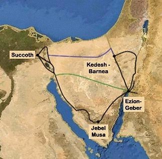
| Описание | Exodus Map c. 14th century BCE.
| ||
|---|---|---|---|
| Источник | Map generated based on image from: http://www.planiglobe.com
| ||
| Время создания | Отсутствует информация о времени создания! | ||
| Автор или правообладатель | <tbody></tbody>
| ||
| Другие версии файла | — |
Источник файла — сайт Wikimedia Commons, куда он был загружен под одной из свободных лицензий ( https://commons.wikimedia.org/wiki/File:Exodus_Map.jpg ). Авторов, работавших над этим файлом см. в истории файла: https://commons.wikimedia.org/w/index.php?title=File:Exodus_Map.jpg&action=history
В общем случае в статьях энциклопедии Руниверсалис файлы используются в соответствии со статьёй 1274 Гражданского кодекса Российской Федерации.
История файла
Нажмите на дату/время, чтобы увидеть версию файла от того времени.
| Дата/время | Миниатюра | Размеры | Участник | Примечание | |
|---|---|---|---|---|---|
| текущий | 10:50, 15 августа 2023 |  | 323 × 317 (31 Кб) | I, Robot (обсуждение | вклад) | == Описание == {{Изображение | описание = <p>Exodus Map c. 14th century BCE. </p> <ul><li>The map shows the standard 3 alternative possible routes for the first part of the Israelite exodus.</li> <li>The inclusion of Jebel Musa is a very recent tradition.</li> <li>The "Sinai peninsula" has only had that name since Christian times.</li> <li>Modern archeologists contest the existence of a mass exodus altogether (see Finkelstein and Silberman, <i>the bible unearthed</i>, The free press, New-Yor... |
Вы не можете перезаписать этот файл.
Использование файла
Следующий файл является дубликатом этого файла (подробности):
- Файл:Exodus Map.jpg из на Викискладе
Следующие 2 страницы используют этот файл:
